I’ve been creating a series of memories and researching the history of Lake Naomi, Pocono Pines, and the greater Pocono Mountains area. While some call me a historian, I’m more of a researcher who shares what I find, and it’s grown into a serious hobby with over 500 pieces of research published on the web. But this one is personal and tied to my childhood, so I hope you enjoy. The interactive maps are an extension of the research and grow as new images, exact locations, and research become available. They’re interactive when there’s a bunch of research to share. We’ll also add more historical physical maps as we track down digital versions.
As the years pass, it’s remarkable how memories play such an essential part in your life, your family, your friends, and your stories. This is one of those tales I just couldn’t let go of because while I haven’t been back to Lake Naomi for a long time, I have friends and acquaintances who bring it up after seeing some of the history my family and I left behind in the community.
My family’s Pocono journey actually began when I was a little more than a year old. It seems that my father, who was a commercial banker in NYC at the time, was commuting home to Jersey on the train when he read an advertisement in the New York Times offering lots for sale for $1,000 on this place called Lake Naomi in the Poconos, a new development that was in the early stages being offered by this guy named Logan Steele from nearby Summit, New jersey.
My Memories Growing Up On Lake Naomi
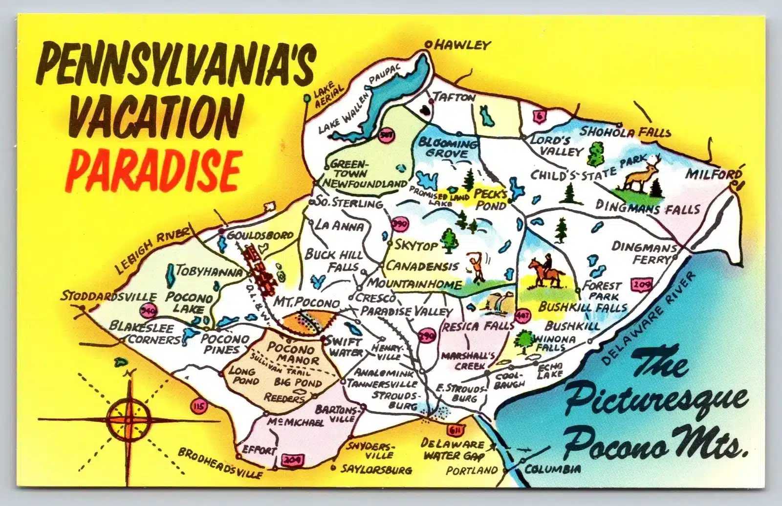
My first task when starting this series was to create a list of places and things I remember doing around the lake in the 1960s. The map showcases where I picked blueberries, rock climbed, rode my bike, played golf, and more. Added images where I could find them. If you want to see my list of memories and how it might compare to one you should create, the story is below as well.
The Poconos Before the Dams
I got to thinking, while it’s great that all the recreational lakes exist in the Poconos today, “I wonder what those rivers would have looked like if the manmade dams weren’t constructed?”. Raised on Lake Naomi in Pocono Pines, I often got to see what the Upper Thaponnock River might have looked like as I climbed rocks in the emptied bed of Lake Naomi, as it would be drained during certain winters for dam maintenance. Still looking for those photos though, so if you have any, I’d love to see them.
Then I began to think, where did the river go next, and where did it end up? I know this because, as my geography teacher taught me, “All rivers end up in the ocean. So let’s see where it does go.
Timeline That Set the Foundation of the Lake Naomi Community Today
The History of the region with 8 points of reference:
- 2.6 million – 11,700 years ago – The Pleistocene Ice Age carves the Pocono Plateau.
- c. 10,000 years ago – Paleo-Indians arrive after the glaciers recede.
- c. 1500s – The Minsi Lenape hunt, fish, and forage on the plateau.
- 1779 – General John Sullivan blazes the Sullivan Trail during the Revolutionary War.
- 1803–1818 – The Wilkes-Barre and Easton Turnpike opens the region to stagecoach travel.
- 1893–1939 – The Wilkes-Barre and Eastern Railroad carries coal, lumber, and ice across the plateau.
- 1910s–1920s – Route 940 is laid out, bringing the first vacationers by automobile.
- 1963 – Logan Steele develops the Lake Naomi community, ushering in a new era of recreation.
The Gilded Age Map of Lake Naomi
Travel back on this map to see images of the great ice harvesting, railroad development, lake creation, religious retreats, and more.
1880s- The Railroads
Industry & Tourism in the Pocono
Before there was tourism, there was industry. Logging, sawmills, and ice harvesting gave way to lakes, trails, and vacation homes. See how the railroads were putting their mark on the Pocono Mountains. Once we get the railroad map finalized, we’ll import to override the current railroad configuration on this map.
The Logan Steele Lake Naomi Era (1963-1984)
Lake Naomi was a quiet Pocono Mountain community until Logan Steele came to town and put a permanent mark on the mountain with his Lake Naomi and Pocono
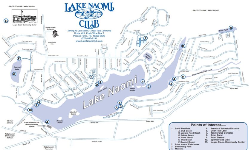
Lake Naomi Today
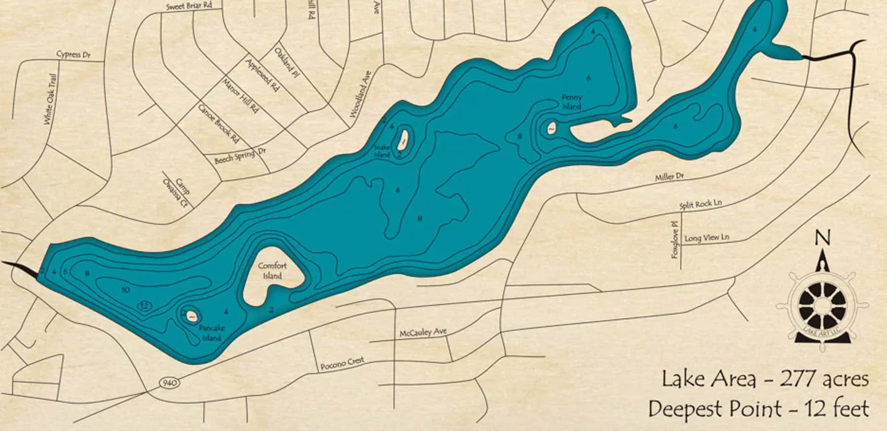
Check out this interactive map. Click the square in the upper right to enlarge and click on the markers.
Digitized Physical Maps
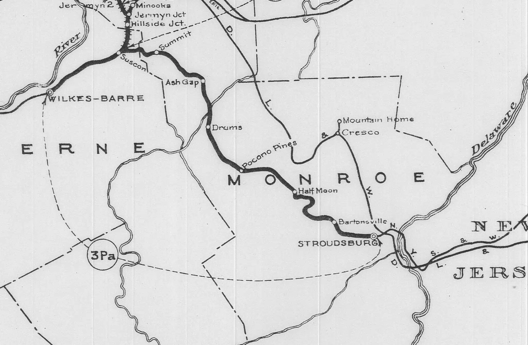
This map is likely the one that best defines the history of what would become the Pocono Pines and Lake Naomi Region of the Pocono Plateau. As you’ve seen, the Ice Age left what was always known as a swamp on the plateau. The 1779 map showcases the red trail that would later become part of the stagecoach turnpike, the railroad, and the auto highway system we know today.

Map of the counties of Monroe and Carbon, Pennsylvania Loomis, Way & Palmer, 1860
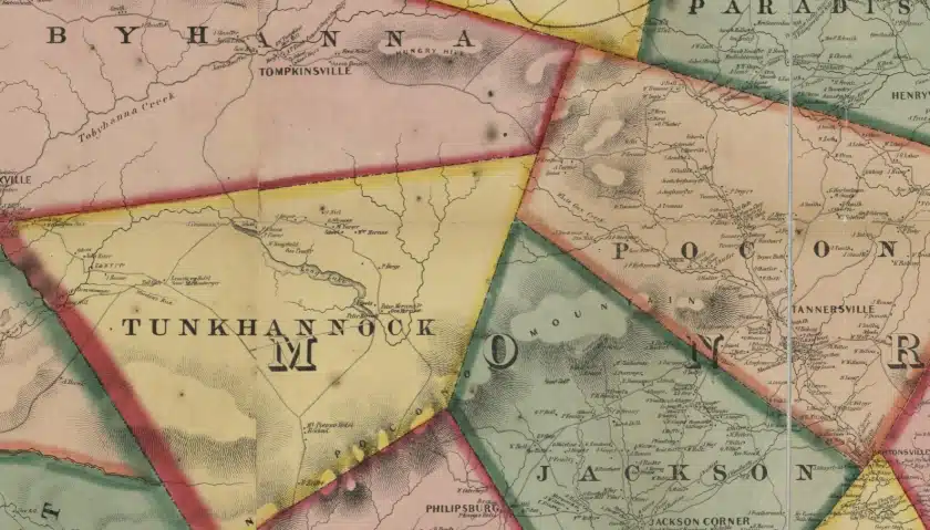
This 1860 map captures a portion of northeastern Pennsylvania—specifically parts of present-day Monroe County (Pocono, Paradise, Jackson townships) and Luzerne County (Tunkhannock Township)—well before modern resort development or the creation of Lake Naomi.
Several interesting historical points stand out:
1. Pre-Lake Naomi Landscape
- In 1860, the area that would later hold Lake Naomi was still a forested upland plateau without any large artificial lakes. Lake Naomi was not created until 1895 when the Miller family dammed the Tunkhannock Creek for ice harvesting.
- The map shows streams such as Tobyhanna Creek and Tunkhannock Creek in their natural, pre-dam courses.
2. Sparse Settlements
- The map is dotted with the names of property owners rather than town names, a common mid-19th-century cartographic style. This indicates how rural and unsettled this part of the Poconos was at the time—made up of small farms, sawmills, and hunting lodges.
- Hamlet names like Tobyhanna Mills and Henryville appear, but many familiar modern communities are absent or much smaller.
3. Early Roads and Trails
- The few roads shown are narrow connectors, often following natural ridges or watercourses. They predate modern state highways like Route 940 or Interstate 380. 940 is a greater story tied to the Revolutionary War’s General Sullivan and the Sullivan Trail that still exists today.
- Stagecoach and wagon roads on the Wilkes-Barre Turnpike toll road linked settlements such as Tannersville, Henryville, and Philipsburg (now part of the Delaware Water Gap/Pocono Pines area), but travel was slow and seasonal.
4. Geographic Boundaries
- The colored polygonal divisions represent township and county lines of the time, with Tunkhannock Township (then in Luzerne County) bordering Pocono and Jackson Townships in Monroe County.
- You can see the three-way junction where Monroe, Luzerne, and Carbon counties meet near the southern part of the map.
5. Economic Clues
- Several mills and inns are labeled, such as the Tobyhanna Hotel and W. Pecue’s Hotel, indicating where travelers could find lodging in the otherwise sparsely inhabited highlands.
- The presence of multiple sawmills and lumber references indicates that timber was the dominant industry prior to the arrival of ice harvesting and tourism.
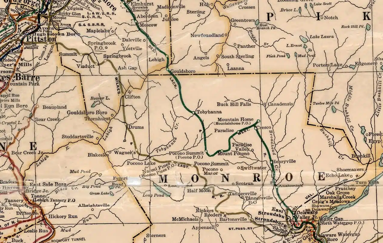
1872 – Counties of Northampton, Carbon, Monroe, and Lehigh, Pennsylvania

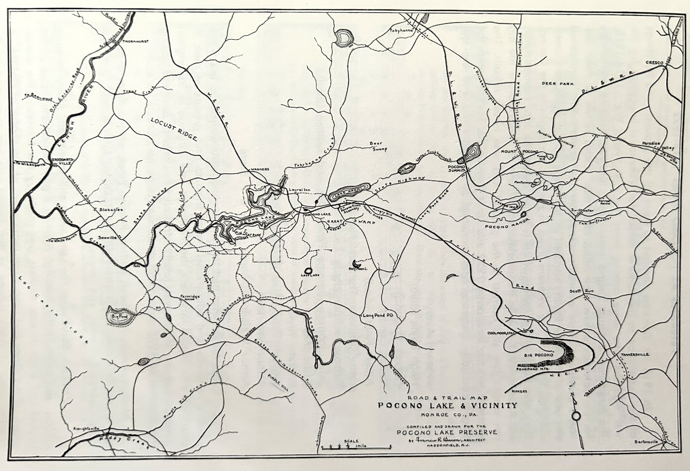
“What to Look For” Guide for readers comparing this historic Pocono Lake & Vicinity map to today’s geography. It can serve as a checklist for spotting vanished, renamed, or transformed features:
1. Vanished or Renamed Railroad Stops
- Naomi Pines, Wagner’s, Reeders, Rinker’s, and Crescent Lake (Half Moon) were once stops on the Wilkes-Barre & Eastern Railroad. None of these appear on modern maps, and the tracks are long gone—now overgrown or replaced by trails and private land.
- Look for the faint, straight line of the old railbed on aerial maps—it often runs parallel to today’s Route 940.
2. Disappeared Water Features
- Bear Swamp and some smaller ponds, as shown here, have been drained or reduced in size due to changes in land use and drainage.
- Some of these wetlands were later dammed or reshaped into artificial lakes for resorts or private communities.
- The winding shape of Pocono Lake on this map reflects its pre-modern shoreline; today its edges have been altered by development and docks.
3. Early Road Alignments
- The main roads here do not match the exact routes of modern highways. For example:
- The road between Pocono Summit and Tobyhanna curves differently from today’s PA-940.
- Connections from Tannersville toward Big Pocono are indirect compared to today’s Route 715.
- Some trails and dirt roads drawn here have vanished into private forest land or state game lands.
4. Forgotten Place Names
- Locust Ridge, Deer Park, and Long Pond PO were well-known local markers but have largely disappeared from everyday use.
- Big Pocono is now known for Big Pocono State Park, but in this era, it was labeled simply for the mountain, with contour lines emphasizing its prominence.
5. Pre-Park & Pre-Resort Landscape
- This map predates the expansion of Camelback Ski Resort, Pocono Manor Resort, and most gated lake communities. It shows a sparsely populated, heavily forested landscape dotted with only a few farms, hunting lodges, and inns.
- The emphasis on trails and the Pocono Lake Preserve suggests the area’s early recreational appeal was tied more to hiking, fishing, and rustic cabin stays than to large-scale tourism.
6. Orientation Clues
- Compare the large looping roads and the rail line to modern GPS maps. You’ll see that while many old alignments are gone, some roadbeds became the base for present-day routes.
- The sharp, snaking path of Tobyhanna Creek is still visible today, making it one of the easiest “anchors” for aligning this old map with modern geography.
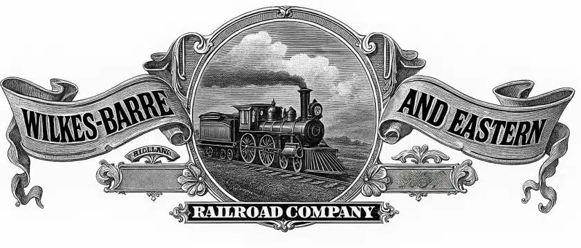
Railroad Maps

A typical c.1905 run from Hoboken would head west on the Morris & Essex main line through Newark Broad Street and onward via Summit → Morristown → Denville (staying on the main, not the Gladstone split). From there it continued to Dover and across northwestern New Jersey on the DL&W’s pre-Cut-Off “Old Road,” passing Lake Hopatcong/Port Morris → Netcong → Hackettstown → Port Murray → Washington → Oxford Furnace → Bridgeville → Manunka Chunk → Delaware/Portland to reach the Water Gap. Once in Pennsylvania, it ran the Pocono Mainline through East Stroudsburg → Stroudsburg → Analomink → Henryville → Mount Pocono, finishing at Pocono Summit.
Around 1905, that trip on the DL&W would have:
- Time: roughly 4 to 4½ hours on the pre-Cut-Off “Old Road” route.
- Fare: about $2.35 one-way in coach (around $70 today when adjusted for inflation).
Express trains might shave 15–20 minutes off, but the Old Road had a lot of curves and grades, so it wasn’t a fast dash through the Poconos until the Cut-Off opened in 1911.
Pocono Pines Assembly – Early 1900s
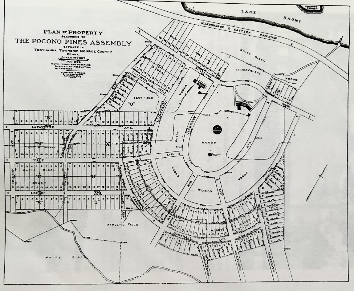
When reading this map, there are several details that reveal both the design and the spirit of the early Pocono Pines Assembly:
- Lake Naomi & the Railroad Connection – At the top, you’ll see Lake Naomi with the Wilkes-Barre & Eastern Railroad running along its southern shore. This rail line was the lifeline that brought guests from New York, New Jersey, and Pennsylvania directly to the community.
- Central Green & Woods – The large oval labeled “Woods” in the center was the heart of the plan, serving as open space for gatherings, shaded walks, and community events.
- Athletic & Recreation Areas – Look for the athletic field at the lower left, the tent field near the top left, and tennis courts just east of the central green — reminders that outdoor activity was central to life here.
- College-Named Avenues – Street names like Lafayette, Yale, Lehigh, Dickinson, and Princeton hint at the Assembly’s educational and cultural aspirations.
- Lot Layout – The neat grid and concentric street circles show a planned balance between private cottages and communal green spaces.
- White Birch Tracts – Several areas, particularly near the southern edge, are labeled “White Birch,” suggesting either wooded preservation areas or undeveloped land.
- Historic Development Style – The absence of large roads for automobiles reflects a pedestrian-centered design from a time when visitors mostly arrived by train and traveled on foot.
It’s a map worth studying slowly, each label and curve tells part of the story of how a century-old resort community was carefully imagined and brought to life.
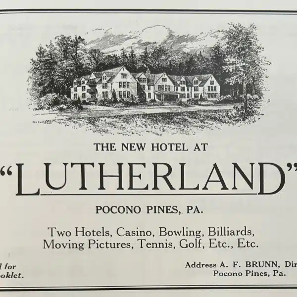
Lutherland Map – c1930
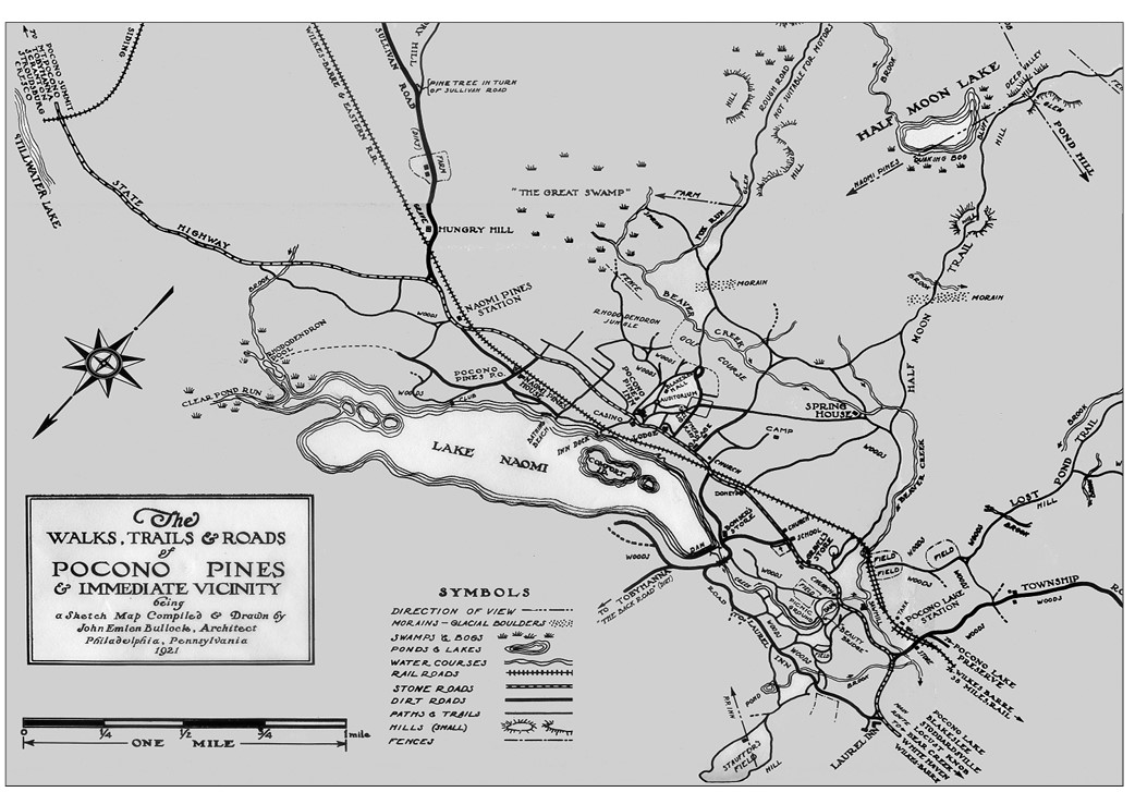
This 1921 map, titled The Walks, Trails & Roads of Pocono Pines & Immediate Vicinity, was compiled and drawn by Philadelphia architect John Emlen Bullock. It serves as both a travel guide and a visual record of the Lake Naomi region at the height of its early resort era.
Here’s what viewers should look for:
- Lake Naomi as the centerpiece – The lake dominates the lower center of the map, with detailed shorelines, islands, and labeled landmarks like the Casino and the Spring House.
- Half Moon Lake – In the upper right corner, Half Moon Lake is shown with its dam and surrounding hills, connected by trails and roads to Lake Naomi.
- The Wilkes-Barre & Eastern Railroad – Clearly marked, this rail line connected visitors from distant cities to Naomi Pines Station and other nearby stops, making the area accessible before widespread automobile travel.
- Named landscapes – Locations like The Great Swamp, Hungry Hill, Rhododendron Jungle, Lost Hill, and Pine Tree in Turn of Julliard Road add character and a sense of place.
- Trails, roads, and paths – The map distinguishes between stone roads, dirt roads, and footpaths, illustrating the rustic transportation network of the era.
- Symbols key – The legend at the bottom left decodes features like swamps, bogs, ponds, lakes, moraines, and fences, which were important for navigation in the early 20th century.
- Surrounding communities – Names like Pocono Lake, Naomi Pines, and Laurys are scattered on the edges, situating Lake Naomi within a broader network of settlements.
Heritage Historic Marker Trail Map

Comments?
What Do These Maps Tell You?
Feel free to post any comments or memories in the comments section below.
About The Author

Brooks founded Mr. Local History and the Mr. Local History project along with his wife Jill. Born in Plainfield, New Jersey, and raised in Westfield, Brooks graduated from Westfield High School in 1980 and later from Bryant University. For over two decades, Brooks, along with his brother Brian and younger sister Cee Cee, spent their summers on Lake Naomi with their parents, Frank and Caryolyn Betz, who had lived on Canoe Brook Road since the mid-1960s.
He and his family owned the Pocono Boathouse (Pocono Pines, PA) and the Cranford Canoe Club in the 1960s through the 1990s.
There are likely many gaps in the history that I hope to fill, along with a return visit to Lake Naomi to reminisce and reflect on these stories. This story is part of a series dedicated to the history of Lake Naomi, Pocono Pines, and the memories of my family spending time together. Thanks for reading.


My Lake Naomi /Pocono Pines Area History Series
Lutherland – Once the Poconos Wonderland Retreat
Views: 1,375 From the outset, Lutherland was promoted not only as a summer retreat but as a year-round destination for religious conferences, youth programs, and leisure activities, a place that blended the mission of Christian fellowship with the amenities of…


Lake Naomi Clubhouse – Pocono Elegance & History
Views: 1,556 For generations, the Lake Naomi Clubhouse has stood as the heart and soul of community life in Pocono Pines, a beloved gathering place that has evolved alongside the families who call this mountain retreat their home away from…

Lake Naomi & the Poconos – A Personal Pocono History Series
Views: 3,393 The series I’ve been researching began as an effort to rebuild my youthful memories of growing up on Lake Naomi in the Poconos starting in the 1960s. As the stories came together, I wanted to start an online…

Memories Growing Up On Lake Naomi and Pocono Pines, PA
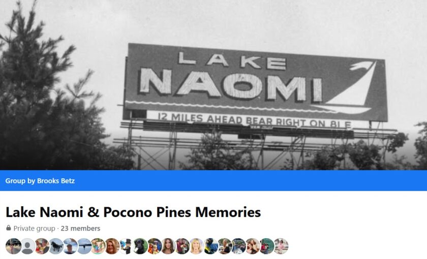
Views: 3,648 This story is part of a series I’ve been researching, as I rebuild my youthful memories growing up on Lake Naomi in the Poconos. As the series comes together, there is an associated Facebook Group, called Lake Naomi Memories,…
Pocono Lake vs. Lake Naomi – Tale of Two Lake Communities & Religious History
Views: 996 Nostalgic & Personal As a kid, summers at Lake Naomi were my whole world. That’s where I first learned to handle a Sunfish, skimming across the water with the wind in my sail. Just down the road was…

The Sunfish Sailboat – Fortune Magazine’s Top 25 Best Designed Products
Views: 1,021 Picture it: a warm afternoon on the water, a flash of colorful sail skimming across the waves. Chances are, it’s a Sunfish, the little boat that became a global phenomenon. By 1977, a year after OpSail in NYC…

What’s The Pocono Plateau- Visiting a Beautiful Ice Age Remnant
Views: 931 While the summer is a beautiful time for recreation in the Poconos, the fall is IMHO the most beautiful time in the Poconos. No need to drive all the way to Vermont, you’ve got it right here in…

Pocono Postcard Collection – My 250+ Memories
Views: 2,001 Don’t you just love getting a postcard? You know them… that picture you’d get in your mailbox from back in the days when getting one put a smile on your face. Welcome to my online postcard and photo…

Pocono Business Advertisements We Love To Remember
Views: 1,098 Help us, old folks, remember all those great businesses around Lake Naomi and the Pocono Pines region that you love and cherish. This story is part of a series I began as an effort to rebuild my youthful…

Lake Naomi’s KonTiki – Honoring the Club’s Race Committee and That Boat
Views: 1,483 This series began as an effort to rebuild my youthful memories of growing up on Lake Naomi in the Poconos starting in the 1960s. As the stories came together, I wanted to start an online dialog with others…

Meet The King of the Poconos- Isaac Stauffer
Views: 1,186 Introduction In the mid-19th century, the Pocono Plateau was still a rugged wilderness, characterized by dense forests, hidden lakes, and scattered clearings carved out by lumbermen’s axes. It was here that Isaac Stauffer, born in 1834 near Wind…

Lake Naomi Icon – Rufus W. Miller, Assembly Visionary, Developer, Religous Icon
Views: 1,308 In the early 1900s, the quiet mountain community of Pocono Pines found its voice through the vision of Rev. Rufus W. Miller, a learned clergyman whose passion for education and spiritual fellowship reshaped the lakeside village. A genuine…

Great Books – Lake Naomi & Pocono Mountain History Collection
Views: 1,377 First off, a very special thank you to Win Miller, Connie Waygood Borho and John Sling for helping me by providing me copies of their books about Lake Naomi history, as I looked everywhere to find these historical recollection booklets…

OMG – Memorytown USA in the 60s – Remembering the Mt.Pocono Icon
Views: 2,320 Step Back in Time at Memorytown USA Tucked away in the rolling hills of the Pocono Mountain region of Pennsylvania, Memorytown USA was once one of the most beloved family attractions in the Poconos. From the 1950s through…

Sailing Tropies History & Lake Naomi Club Sailing Association
Views: 1,325 Throughout the 1920s and 1930s, Lake Naomi gained popularity, attracting families, religious groups, and campers, including young girls who participated in summer programs that included sailing lessons. Yet it wasn’t until 1963 that the lake’s future was truly…

1892 – Getting to the Poconos – Taking The Train
Views: 1,307 Many of us forget that the automobile didn’t really start gaining a presence until the 1920s, so getting around was either by rail or horse-drawn carriage. So if you were coming from Philadelphia or New York City to…

Pocono Boathouse History – A Lake Naomi Institution
Views: 2,093 The First Pocono Boathouse The story of the Pocono Boathouse retail establishment begins when, in 1965, Frank and Carolyn Betz built a chalet on the north side of Lake Naomi and opened a small but ambitious boating business…

Retrospective: Lake Naomi, Pocono Pines and The Logan Steele Era 1963- 1986
Views: 1,881 While my parents caught wind of Lake Naomi in 1963, Logan Boone Steele of Summit, New Jersey, had a vision and became one of the first developers of the modern era in the Pocono Pines area of the…

The Team That Made the Lake Naomi Development/Community
Views: 1,372 Little background first: In 1895, Lake Naomi was created when Thomas and Rufus Miller constructed a 14-foot dam across Tunkhannock Creek in the Pocono Mountains of Pennsylvania. Initially intended for ice harvesting and modest recreation, the resulting lake…

Meet Logan & Lee Steele: Visionaries of Lake Naomi and Timber Trails
Views: 1,370 Meet Logan and Lee Steele, the couple behind one of the Poconos’ most beloved private communities, Lake Naomi. Logan Steele wasn’t just a visionary developer; he was a man who saw a wild stretch of woods and lakes…

Pocono Pines and Early Lake Naomi -The Gilded Age (1870s-1963)
Views: 3,407 As America surged through the transformative decades of the Gilded Age, from the 1870s through the early 1900s, the tranquil forests and mirrored lakes of Tompkinsville and Tobyhanna emerged from obscurity to become a sought-after escape for the…

Lake Naomi Way Before the Dam
Views: 1,612 Map of the 1779 Sullivan Trail – Click the map to see a blow-up of the trail that ran right through Pocono Pines and the region. This map is likely the one that best defines the history of what…

Lake Naomi- The Millers & A House That Defined a Destination
Views: 1,418 What started out as one story has now become a collection. Now that the founding narratives have been documented in my series, this story has come to light due to its significance to the history of Lake Naomi,…
Pocono Spring Water Ice Company – The Millers & Naomi Lake
Views: 1,712 The Miller brothers, Franklin and his younger brother Rufus, were part of the Miller family from Easton, Pennsylvania. Younger brother Rufus struck out on a religious career as a minister, and Franklin (Frank) had other ideas. Bigger ideas.…

Growing Up at the Cranford Canoe Club
Views: 25,495 The Mr. Local History Project is determining interest to nominate the Cranford Canoe Club to the New Jersey Historic Registry. If you believe this should be done, please consider signing our petition to let Cranford local officials that…
On the Way to the Poconos, we had to use Route 22 to 611 to 940….ah the days!
Highly Recommended:
Go Stay at the Mountaintop Lodge at Lake Naomi – https://mountaintoplodge.com/
What Others are Reading Right Now on MLH
Top 10 “Most Popular” Posts