General Washington, the Continental Army, and General Lord Stirling of Basking Ridge took a page from the history books and created a sophisticated communications network to highlight the British movement. They were called the “Beacons.”
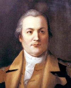
You never know what you’ll find regarding history in the Somerset Hills area of northern Somerset County, New Jersey. However, we have another great story of the American Revolution and its ties to Basking Ridge, New Jersey. For those who don’t know General William Alexander, also known as Lord Stirling of Basking Ridge, New Jersey is the one credited with designing the famed “Continental Army Beacons” to signal across two states that the British were on the move. From West Point on the Hudson in New York to the southern tip of the Watchung Mountains, bonfire pilings or ignitable tar barrels and cannons were placed on the mountain ridges. These were Stirling’s Beacons.
Trinity Churchyard
New York City.
The Beacon Concept
The beacon concept is not new. In the 10th century, during the Arab–Byzantine wars, the Byzantine Empire used a beacon system to transmit messages from the border with the Abbasid Caliphate, across Anatolia to the imperial palace in the Byzantine capital, Constantinople. It was devised by Leo the Mathematician for Emperor Theophilos, but either abolished or radically curtailed by Theophilos’ son and successor, Michael III. Beacons were later used in Greece as well, while the surviving parts of the beacon system in Anatolia seem to have been reactivated in the 12th century by Emperor Manuel I Komnenos.
Another reference to the systematic use of fire signals to transmit messages can be found in the Greek army’s descriptions of the siege of Troy, which is now assumed to have taken place in approximately 1184. At least three different sources, Homer, Aeschylus, and Vergil, describe such signaling methods, sometimes in elaborate detail. One of the oldest sources is Homer’s Iliad, written in approximately 700. It contains the following passage:
‘Thus, from some far-away beleaguered island, where all day long the men have fought a desperate battle from their city walls, the smoke goes up to heaven; but no sooner has the sun gone down than the light from the line of beacons blazes up and shoots into the sky to warn the neighbouring islanders and bring them to the rescue in their ships.'”
Homer’s Iliad, written in approximately 700
Even in J. R. R. Tolkien’s high fantasy novel The Lord of the Rings, a series of beacons alerts the entire realm of Gondor when the kingdom is under attack, so they must work! Let’s not digress. In 1779, when George Washington moved the Continental Army into New Jersey, twenty-three beacons were commissioned and built under the direction of Major William Alexander.
Beacons in The Watchung Hills
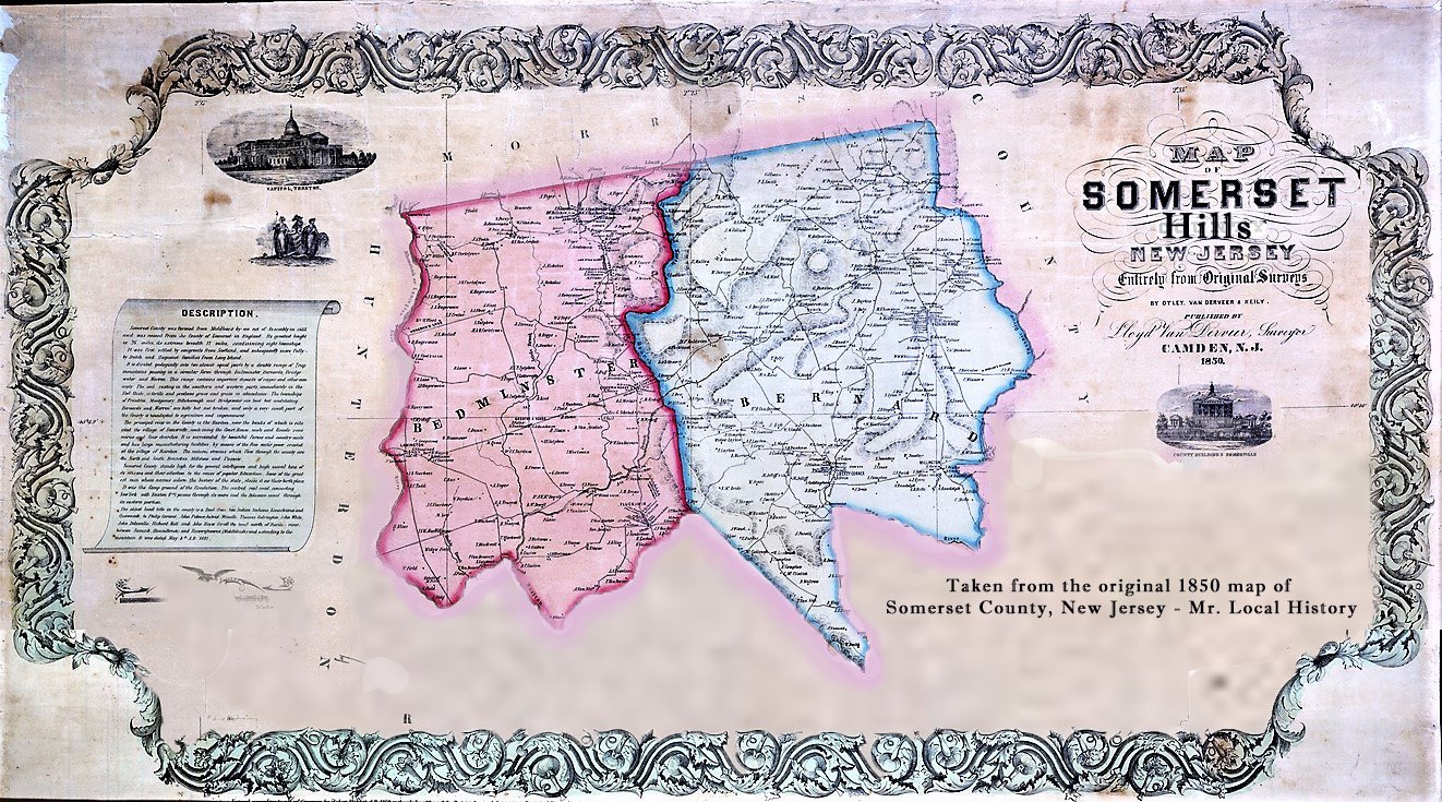
The Watchung Mountains are a multi-ridged mountain chain. Often referred to as the “Blue Hills” they were the hills that protected Washington and it was a brilliant judgment call. To protect the army from a surprise attack by Gen. Clinton’s forces out of New York, he ordered General Alexander, Lord Stirling to put together a plan for a series of signal beacons to be built “on conspicuous hills and Mountains, which appear to be judicious and well disposed” on the eastern side of the Watchung Mountains then called the Blue Hills of New Jersey. While the map showcases the approximate locations, they are not the “exact” locations.
Head Quarters [Middlebrook] 23d March 1779
My Lord (Major General Stirling)
I should have issued orders for the fatigue parties intended to erect the Signals to assemble tomorrow but I was not certain that the Guides would be ready. Instead therefore of a general Order for the purpose, I would propose that you give directions to the parties from Woodfords and Scotts to erect the Signals at Steels Gap and the Hill upon Baskenridge Road. I will desire Genl Smallwood to furnish parties from the Maryland Brigades to erect those at Waynes, Lincolns and Quibble town Gaps, and shall refer the Officers to your Lordship for the proper construction of the Beacons—Be pleased to direct Burrel who is to guide the party from the Penna line to the Hill near princetown to attend at Genl St Clairs quarters tomorrow morning at 8 OClock. I imagine the Signal No. 8a and 8b were to have been erected by Muhlenbergs Brigade upon a supposition that they remained below. But as they have returned to Camp, some other Corps most convenient must undertake it. I shall write to Genl Knox to have the Pluckemin Signal erected.
Head Quarters [Middlebrook] 23d March 1779 – From George Washington to Major General Stirling, 23 March 1779

Each of the beacons are to be of the following dimensions: at bottom, fourteen feet square, to rise in a pyramidal form to about eighteen or twenty feet high, and then to terminate about six feet square, with a stout sapling in the center of about thirty feet high from the ground.
The following logs to be cut as near the place as possible: twenty logs of fourteen feet long and about one foot diameter; ten logs of about twelve feet long; ten logs of about ten feet long; ten logs of about nine feet long; ten logs of about eight feet long; twenty logs of about seven feet long; twenty logs of about six feet long. He should then sort his longest logs as to diameter, and place the four longest on the ground, parallel to each other, and about three feet apart from each other. He should then place the four next logs in size across these at right angles, and so proceed until all the logs of fourteen feet be placed. Then he is to go on in the same manner with logs of twelve feet long, and when they are all placed, with those of lesser size, till the whole are placed, taking care, as he goes on, to fill the vacancies between the logs with old dry split wood or useless dry rails and brush, not too close, and leaving the fifth tier open for firing and air. In the beginning of his work to place a good stout sapling in the center, with part of its top left, about ten or twelve feet above the whole work. The two upper rows of logs should be fastened in their places with good strong wooden plugs or trunnels.
General Alexander (Lord Stirling Letter) – Benson John Lossing, The Pictorial Field-book of the Revolution (New York: Harper and Brothers, 1852
The town of Summit, despite the name, is not the highest elevation in the Watchung Mountains; that distinction belongs to Preakness Mountain in Wayne. The New Jersey mountains run from Campgaw Mountain in Mahwah, to Pill Hill in Far Hills. Their high points allowed Washington’s troops to monitor British troop movements from New York to New Brunswick, and respond by moving men toward conflict behind the safety of the mountains which is why George Washington spent approximately 3 1/2 years of the eight-year war in and around these mountains.
From General Washington to Brigadier General Henry Knox while Knox was at Pluckemin Cantonment in 1779.
Dear Sir,
For the more speedy assembling of the Militia upon an emergency, I have agreed with the Field Officers in this and the next County to erect Beacons upon the most conspicuous Hills, the firing of which shall be signals for them to repair to their different Alarm Posts—You will be pleased to have one erected upon the Mountain in the Rear of Pluckemin, upon the place that shall seem most visible from the adjacent Country. The Beacons are proposed to [be] built of Logs in the form of a Pyramid, 16 or 18 feet square at the Base, and about 20 feet in height, the inner part to be filled with Brush—Should there be occasion to fire it you shall have proper notice.
Be pleased to send me one of the Copies of the last Arrangement of the Ordnance department. I am Dear Sir Yr most obt Servt
Go: Washington
P.S. As The inclosed Resolve of Congress includes the Artillery I have transmitted to you, and request you to order Returns to be made agreeable thereto.
From George Washington to Brigadier General Henry Knox, 23 March 1779
Head Quarters [Middlebrook] 23d March 1779
The Beacons Worked
Twenty-four men, detached from the regiment encamped nearest to the selected location, took one day to cut the needed trees and complete the construction.
The Watchung Mountains were a natural fortress; combined with Lord Stirling’s beacons, the mountains became an impregnable line of defense. In June of 1780, two British attempts were made to attack Washington’s encampment at Morristown by sending troops from Staten Island to Elizabethtown Point, New Jersey, and from there through the Hobart Gap in the Watchungs at the Battle of Springfield. Both attempts failed largely because New Jersey militia could mobilize quickly and swarm to the threatened area. The beacons proved their worth, and the British could never dislodge Washington or penetrate his defenses.

Three lesser-known battles revolved around the Watchungs. First was the Battle of Bound Brook, on April 13, 1777, when the British came up from New Brunswick to attempt to control the upper Raritan River at the base of the mountains. The British were somewhat successful, but not enough to hold the position.
The British again tried to penetrate the mountains during the Battle of Short Hills, in what is today Scotch Plains, on June 26, 1777, after Washington moved his troops from behind the second ridge of the mountains in Morristown, to behind the first ridge at Middlebrook. His headquarters was in the Nathaniel Drake House in Plainfield.
The final British push into the Watchungs came during the Battle of Springfield, in late June of 1780. Under the command of Prussian General Baron Von Knyphausen, 6,000 British, Hessian, and Loyalist soldiers maneuvered up what is today Morris Avenue and Vauxhall Road in an attempt to climb the Hobart Gap and attack Washington in Morristown. It was unsuccessful.
So here it is. In our Watchung Mountains, George Washington won the war of attrition. The hills’ protection and the great swamps between them kept the British at a long arm’s length for almost half of the war’s duration.
Beacon Celebrations
On November 25, 2008, to celebrate the 225th anniversary of the evacuation by British Troops, instead of lighting fires, a group of organizations recreated eleven symbolic Xenon light displays that lit up six New Jersey beacon areas and five in the Hudson River Valley National Heritage Area to honor “the beacons” honoring evacuation day, the day the British formally left America back on November 25. 1783.
At a second effort on November 25, 2009, thirteen Xenon Skytracker searchlights stretched for 108 miles between Princeton, New Jersey, and Beacon, New York, with eight sites in New Jersey and five in New York. The first event took place last year in 2008, prompted by its 225 anniversary. It also was a chance to work with other historic parks and sites that are part of the story of the American Revolution, according to Cate Litvak, Director of the Cross Roads of the American Revolution.
In New Jersey, the following sites were lit in 2008:
- Princeton Academy of the Sacred Heart
- Washington Rock State Park, Greenbrook
- Beacon Hill Club, Summit
- Beacon Hill, Denville
- Ringwood State Forest in Oakland
- Twin Lights, Navesink
In New York, the following sites were lit in 2008:
- Fort Montgomery State Historic Site
- Cornwall-n-Hudson Landing
- Boscobel Restoration
- Constitution Island
- Mount Beacon
The total project area stretched from Princeton, NJ to Beacon, NY. The project took place over three years and was also part of the larger interstate effort with national heritage area partners in New Jersey and the Crossroads of the American Revolution National Heritage Area.
Other beacons have been referenced in memoirs, letters, and orders, but this author has not been able to place them in the above twenty-three. They are Kettle Hill in Connecticut Farms, McGee’s Hill in Elizabeth, Warren Beacon at Mount Bethel, Gouverneur Mountain in Ringwood, Bottle Hill in Madison, Federal Hill in Pompton, Beacon Hill near Parsippany and Green Pond Mountain.
Honoring The Beacons
- Beacon #1 “A Longe fire on the Mountain in the rear of Pluckemin” (Bedminster)
- Beacon #2 “One on the mountain near steak [Steel] Gap”
- Beacon #3 “One on the mountain near Mordicas or Wayn’s Gap”
- Beacon #4 “near Linelons [Lincoln’s] Gap”
- Beacon #5 “one near Quibble Town Gap” [at Washington’s Rock Lookout]
- Beacon #6 “on the Hill the road to Baskin-Ridge four miles north of Col. Van Horns” (Bernards Township) (This actually might be Pluckemin since Van Horn’s house was in Bridgewater).
- Beacon #7 “on the Hill toward Princetown”
- Beacon #8 “one on the Hill in front of Marten Taverns near short hills”
- Beacon # 9 “at the point of the mountain north of Springfield one mile under the care of Capt. [Isaac] Gillam” (Maybe South Mountain Reservation?)
- Beacon #10 “on the top of the Hill [Beacon Hill, Summit] one mile south East of Chatham Bridge under the Care of Capt. [Joseph] Norton ” (Hobart Hill, Summit)
- Beacon #11 “at [John] Cooper’s Wind Mill on Long Hill at [Col.] Corn[elius] Ludlows”
- Beacon #12 “at the point of Kenny’s Hill at Morristown [Fort Nonsense]” (Morristown)
- Beacon #13 “on Pidgeon Hill four miles northwest of Morristown.”
- Beacon #14 “on Schuyler’s mountain N. W. of Pluckinin 12 miles.”
- Beacon #15 “on the Hill 10 miles west of Do.”
- Beacon #16 “on the South Point of Cushatunk [Round Hill?]”
- Beacon #17 “on the Hill [Prospect Hill?] N. W. of Fleming towns”
- Beacon #18 “on the N. W. point of the Southern Hill [Goat Hill?] ”
- Beacon #19 “on the Hight of Amwell looking southward”
- Beacon #20 “one on Princetown looking southward.”
- Beacon #21 “on the Carter Hill in Monmouth”
- Beacon #22 “on Middleton Hill”
- Beacon #23 “on Mount Pleasent”
Related Mr. Local History Research
- The Beacon Database
- Pictorial Field-Book of the Revolution by Benson John Lossing
- The Blue Hills Beacons
- N.J., N.Y. 2009 celebrate Revolutionary War anniversary with light presentation – Nj.com
- Beacon Lights and the 30 Years War
- How the Watchung Mountains won the Revolution
- The (Biblical) Beacons of Gondor


Is there any mention of a beacon being placed on hi tor mountain in haverstraw? I’ve read multiple websites saying they used that point for a beacon because of its elevation above the Hudson.