1930s: Bernards Plateau and the 60-acre Bernards Commons & Decker’s Park Community Project

The Bernards Plateau was named for the broad upland just west of the Basking Ridge village center, located just across Route 287 today, an area once filled with corn fields, pastures, and orchards that drew early farm families with good soils and open exposures. By the early twentieth century, the Decker family had acquired a large portion of this land and operated it as a traditional mixed farm, with lanes that later became neighborhood streets, including Decker, Chimney Ash, Brook, and Oak Ridge, among others. Local historians note that the plateau’s name stuck in common use as the area shifted in the 1930s from agriculture to the planned development of an exciting new community.

The Bernards Commons – Wheeler Corporation’s Vision
By the mid-1930s, the old Decker farmland on the Bernards Plateau was ready for change. The Wheeler Corporation of Bernardsville purchased the sixty acre tract from Casper G Decker and set out to create a model neighborhood they called Bernards Commons, a modern community where every home would face shared parkland within a landscaped setting. What’s funny is that Wheeler was advertising the development with a new concept that actually has been a neighborhood design for centuries. The project would undergo several name changes as plans evolved, beginning as Bernards Plateau in 1935, shifting to Oak Commons in 1936, and finally emerging as Bernards Commons by 1938. That same year, Wheeler introduced its showcase home —a new steel-framed design on West Oak Street that reflected the promise of modern suburban living.
The house they were talking about still stands today at 184 West Oak Street, with its brick chimney marked with the year 1938, a lasting reminder of the moment when the quiet Decker farm gave way to one of the earliest planned neighborhoods in Bernards Township. I know because my wife and I bought that house, not knowing the interesting history the house and area would bring us, and now we share it with you.


Bernards Commons Development Timeline
- January 1935 – Casper G Decker of Elmira, New York, is identified as the owner of land south of Oak Street and east of Mt Airy Road. Plans are discussed for a small home layout with parks, streams, and sidewalks.
- March 1935 – Casper G Decker agrees to dedicate land to straighten the intersection of West Oak Road and Mt Airy Road. The township engineer is directed to set new lines and grades.
- April 1935 – Bernards Township affirms an ordinance to create Alward Street, Decker Street, Oak Ridge Road, and Brook Avenue in the Bernards Plateau area east of Mt. Airy Road (affirmed on a September 1935 map in the Somerset County Clerk’s Office.
- September 1935 – The Wheeler Corporation begins marketing Bernards Plateau at Oak Street and Mt Airy Road, with building lots offered for $400 each and a plan featuring parks, playgrounds, and tennis courts. Wheeler offers to build-to-suit with FHA loans.


- June 1936 – Wheeler sells the first bungalow on Oak Street to James W and Beatrice Gray of Summit. Wheeler announces a field office on Oak Commons and another house to start on July 1. Oak Commons appears in print for the first time.
- In July 1936, the Bernardsville Garden Club toured the development. Landscape architect Katrina Haines outlines the completed landscaping and future plans, noting an intention to preserve historic features.
- Spring to summer 1938 – Branding shifts to Bernards Commons, the sixty-acre tract along West Oak Street. Marketing highlights Stran Steel framing and the idea that all homes face parks. Architect Alfonso Alvarez is credited. Materials, including steel, are supplied locally by Nicholas Thomas Lumber in nearby Millington.
- Late 1938 – Construction of what is described as the first steel frame house in New Jersey at 184 West Oak Street in Bernards Commons. One and a half story plan finished in stucco over fire-resistant board with two bedrooms, dining room, kitchen, living room, and a ten-by-twenty open porch. The public is invited to inspect the model.


- Year mark 1938 on site – The house at 184 West Oak Street has 1938 set in brick on its chimney. Form and materials match the steel model description, identifying the house as either the Wheeler steel example or its twin.
- 1939 – Casper G. Decker sold the 60 acres of the Deckers’ Bernards Plateau tract to the Wheeler Corporation, a transfer that set the stage for subdivision along West Oak Street and a wave of modern residential development. Contemporary street name histories explicitly record the sale, and later local write-ups tie the Wheeler development to the nearby steel-framed demonstration house, which helped mark the end of the Decker farm era on the plateau.
What Happened to the Bernards Commons on the Bernards Plateau
Short version. Bernards Commons was only partially realized. The late 1930s plan, featuring park-facing blocks and multiple cross streets, was never fully implemented beyond a few key elements. What survived on the ground are the short Decker Street stub off West Oak, Alward Street to the south, and scattered house lots. The big clues are timing and terrain. The project hit the headwinds of the late Depression and then wartime controls. By 1942, steel and many building materials were rationed, FHA priorities shifted, and small private subdivisions stalled. Add in the stream valley and low ground north of West Oak, which limited easy street extensions, and you get a minimal street grid with a dead-end Decker Street and no full realignment of Mount Airy at West Oak.
Then came Interstate 287 right to the left of the development. Gone was Harrison Park and the Harrison Brook.


What Likely Happened
Researchers assume that several factors may have contributed to the Bernards Common project’s demise. They believe sales likely slowed before the war ultimately halted the building program, leaving unbuilt paper streets and planned park strips to expire or be vacated. It is also assumed that the tract was later replatted into smaller parcels and developed gradually under newer township standards, with Alward Street taking shape to the south while Decker Street remained a short local road. Another assumption is that the planned straightening of Mount Airy Road at West Oak Street never advanced beyond early concepts, with the township instead settling for a modest corner adjustment and limited grading rather than the full curve removal originally proposed.
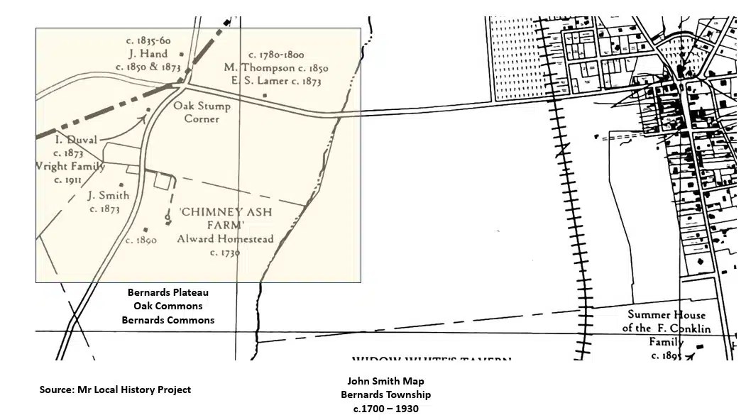
Farm Homes Survived on the Bernards Plateau
Although the larger Bernards Commons plan never reached full buildout, two of the area’s older farmsteads survived, preserving parts of the rural landscape. The old Compton homestead, once part of the original farm grid on the plateau, remained on a smaller lot but still preserved its early domestic core and outbuildings. Nearby, the Chimney Ash Farm also endured, reduced in acreage yet recognizable through its farmhouse and surrounding pasture. Together, these two historic properties bridged the transition from the Decker farmland to the later suburban neighborhood, reminders of the agricultural roots that shaped the Bernards Plateau.


The Alward farmstead centers on the mid eighteen forties Alward Farmhouse at 40 Mount Airy Road in Basking Ridge, one of the township’s earliest surviving dwellings. Research places the core of the house to about 1740 and notes that its lines remain essentially unchanged. It is listed on the New Jersey Register and the National Register as of March 1986. Township history notes that the Alward family was among the first wave of settlers by about 1740.
Title history shows the land passing through the Pennington family to Henry Alward by marriage, with Alward’s ownership lasting until 1872. The homestead appears on Robert Erskine’s Revolutionary-era mapping. The broader Alward name persisted into the twentieth century through H W Alward Incorporated, a major local road and water contractor based on Mount Airy Road. Today, Alward Avenue in Bernards Township carries the family name, and the farmhouse remains a private residence near the Bernards Commons and West Oak Street area you are researching.

More Related MLH Developments Research
Our Readers’ Top 10 MLH Posts this Week


Additional Stories:
 1938 – Wheeler Corporation Builds New Jersey’s First Steel Framed Concrete Stucco Home in Basking Ridge
 Quicklinks – Tracking History From Selected Jersey Towns
 Jersey’s Jared Isaacman – Ridge Dropout Billionaire Astronaut NASA Dream Job Dashed
 The Pope of Basking Ridge – Bill Hine’s Presence Shined