Preview Release:
Additional updates will be added as MLHP researchers provide additional photos, metrics, and history. Please come back to check on the development of this piece.
The origins of one of New Jersey’s most significant planned communities trace back to 1969, when the descendants of financier Grant Schley sold Schley Mountain for $2.2 million. That transaction opened the door for what would become The Hills Development of Bedminster and Bernards Township. Spread across eighteen hundred acres atop Schley Mountain in the scenic Watchung Mountains, the community straddles both townships in Somerset County at the crossroads of Interstates 287 and 78.
First off, you can’t talk about The Hills without first talking about Grant Schley (pronounced “Sh-lie”). Not only did he and his wife start Far Hills, the town next door, but he and his brother Evander also owned Schley Mountain, which became the foundation of The Hills Development. So props first to Grant Schley!
The Runnymede Corporation, a publicly held real estate development firm based in Montclair, began the project by acquiring more than 1,300 acres of land spanning Bernards and Bedminster Townships. The plan was to create a luxury residential community on Schley Mountain, which would eventually evolve into The Hills development. The land, largely owned by the heirs of Grant and Evander Schley through the Far Hills Land Corporation, marked the end of an era for the vast Schley estate holdings that had dominated the area since the late 19th century. Runnymede’s acquisition included eight parcels totaling 1,338 acres, 774 of which came from the Far Hills Land Corporation, and smaller tracts along Route 202–206 and Mount Prospect Road.
To finance the project, Runnymede launched a public stock offering of roughly 550,000 shares at $10 each, aiming to raise about $7.5 million, later adjusted to $4 million, for the purchase and development of the property. The company’s plans included drafting a master plan and seeking new zoning approvals to allow greater housing density than the current three, and five-acre zoning. The proposed community was envisioned as an upscale development built around a championship golf course designed by renowned architect Robert Trent Jones. Runnymede’s leadership included President Arthur Dixon Jr. of Essex Fells, Secretary-Treasurer John McNiff of New York, and Bernardsville real estate broker Theodore Fleming, who oversaw the Runnymede Land Corporation subsidiary managing the Somerset County holdings.
The map legend is on the left (top), and the full screen is the square on the top right.
The Hills is a shared development between Bedminster and Bernards Township, each taking a different path to growth. Runnymede started the project (1968–1971), Bedminster moved forward first, embracing the planned residential concept and building the initial neighborhoods that set the tone for the community. Bernards Township, by contrast, challenged the state’s housing mandate in court, arguing for local control over density and design. Its victory allowed it to shape its portion of The Hills with a more traditional suburban character, avoiding the high-density clusters that defined the Bedminster side.
From 1968 through the early 1970s, the Runnymede Corporation assembled the land and conceived the project. But the plan stalled before construction. Ownership/control of the assembled land would then shift to new investors and holding companies, a consortium operating as The Hills Development Company re-planned and entitled the tract under the emerging Mount Laurel housing mandates, securing the master plan that set the scale and mix of neighborhoods for Bernards and Bedminster. From the late 1980s through the 1990s into the early 2000s, Toll Brothers served as the primary builder, delivering the bulk of the neighborhoods that completed The Hills.
Once the phases were completed, The Hills comprised 4,728 homes spread across thirty-eight distinct neighborhoods, ranging from one-bedroom condominiums priced under $200,000 to six-bedroom estate homes valued well above $2 million. The Basking Ridge section accounts for sixteen neighborhoods and 1,893 homes, set against wooded ridges and open meadows that preserve the natural beauty of the Watchung slopes.
Yet beneath its roads and rooftops lies a deeper story. The same soil that once supported the farms of the Schley family, the troops of General Knox, and the pioneers of the early German Palatines now supports a thriving twenty-first-century community. The Hills may be a modern creation, but it is firmly rooted in the long and layered history of the land it stands upon.
In the late 1960s, the landscape around Bedminster was still an expanse of rolling farmland, horse pastures, and woodlots stretching across the Watchung foothills. That began to change in 1969 when the vast Schley Mountain tract was sold for future development. The land covered thousands of acres west of the ridge and would soon become the foundation for what is now known as The Hills.
By the mid-1970s, Bedminster officials were facing growing pressure to plan for the township’s future. The New Jersey Supreme Court’s Mount Laurel rulings had declared that every community must provide its fair share of affordable housing. For a small rural town like Bedminster, that meant rethinking traditional zoning to allow for new residential development. Out of those discussions came a bold concept: a fully planned community that would balance open space with homes, shops, schools, and recreation.
The Hills Development Company, in partnership with builders like Toll Brothers, broke ground in the early 1980s. Their vision was to create a self-contained village at the foot of the Watchung Mountains. Streets curved naturally with the land, neighborhoods were connected by trails and parkland, and housing types ranged from condominiums to single-family homes.
The development gained statewide attention in 1986 when the case Hills Development Company v. Bernards Township helped define how towns would meet their affordable housing obligations under the new Mount Laurel framework. Bedminster’s portion of The Hills became an early example of inclusionary zoning done on a large scale, with hundreds of affordable units built alongside market-rate homes.
To serve the growing population, The Hills Village Center opened in 1988 along Routes 202 and 206, anchored by Kings Food Market. It quickly became the community’s focal point, offering shops, restaurants, and gathering places that made The Hills Village feel like a small town within a town.
By 1990, Bedminster’s population had tripled. What had once been quiet countryside had transformed into a vibrant community of families, professionals, and retirees. Yet even amid the growth, Bedminster managed to preserve significant tracts of open space, maintaining the balance between development and nature that remains part of its appeal today.
While Bedminster’s section of The Hills developed first, Bernards Township’s portion came later and evolved under a slightly different vision. Situated higher along the Watchung slopes in Basking Ridge, this area presented unique environmental and planning challenges. The land was steeper, the soils thinner, and access more limited, requiring careful design to protect the mountain’s natural contours.
Bernards Township also had its own planning goals. The township sought to manage growth carefully, integrating The Hills into its long-term master plan rather than allowing uncontrolled sprawl. As a result, the Bernards section featured a more suburban character with larger homes, scenic views, and neighborhoods that blended into wooded ridgelines.
Although the Bernards phase shared the same name and overall identity as The Hills, it was distinct in tone and design. It emphasized privacy, open space buffers, and architecture that complemented the ridge’s natural setting. Together, the Bedminster and Bernards portions created a community that crossed township borders but maintained two distinct personalities, one more village-like and accessible, the other more residential and scenic.
When The Hills first rose from the fields of Bedminster and the wooded slopes of Bernards Township, the project faced more than the usual tests of development. What looked, from the outside, like a modern suburban community was actually one of the most complex planning efforts Somerset County had ever seen. Each township encountered its own hurdles, some buried deep in the soil of history, others written in zoning codes, engineering blueprints, and community politics.
“As bulldozers moved in, the past began to surface,literally.”
Mr Local History
In Bedminster, the challenge began long before the first foundation was poured. The township was still adapting to the Mount Laurel decisions, which required every New Jersey community to provide its fair share of affordable housing. To comply, officials had to invent new zoning tools and negotiate carefully with The Hills Development Company. Every approval carried the weight of precedent, as it was known that what happened here might shape housing policy across the state.
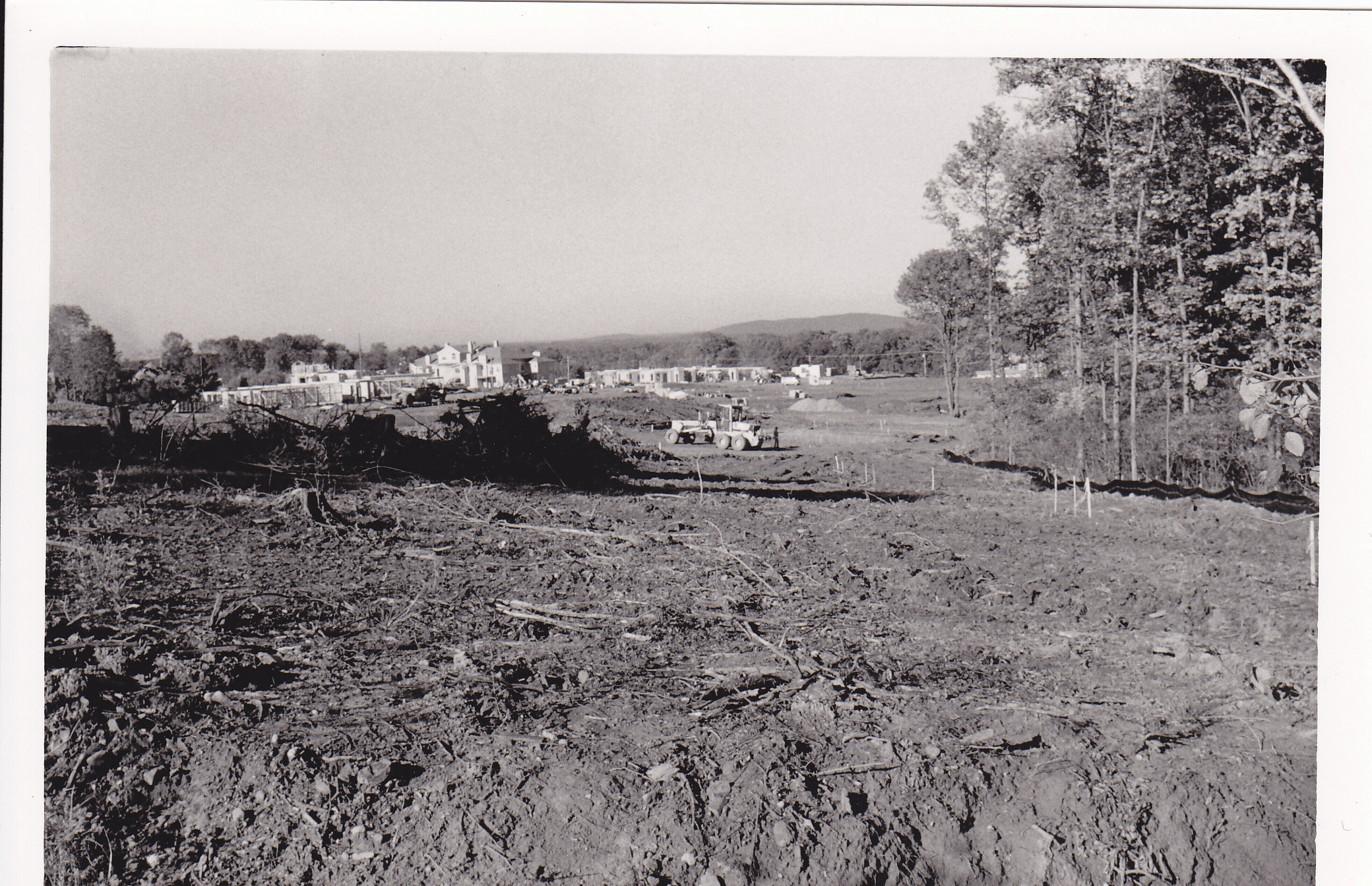
As construction began in the early 1980s, Bedminster’s open farmland was suddenly alive with survey stakes, concrete forms, heavy machinery, and yes, houses. Engineers had to carve entire road systems from what were once cow pastures and rolling meadows, connecting a new village to Routes 202 and 206 without overwhelming local traffic. Sewer and water infrastructure had to be built from the ground up. Stormwater basins, retention ponds, and culverts had to be designed for slopes that turned muddy after every summer thunderstorm. Builders found themselves racing against the seasons, and often against the weather, to keep the site stable and accessible.
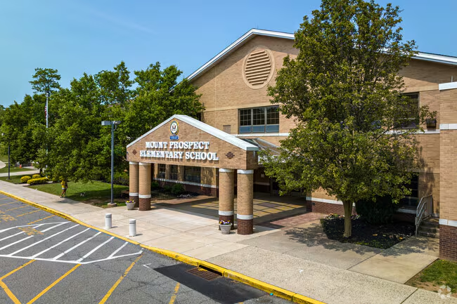
The word “Prospect” was a common 19th-century term for scenic outlooks or high vantage points. The ridge offered sweeping views east toward the Watchungs and west toward the Somerset Hills, so early residents called it “Mount Prospect.” When the township built the elementary school in the 1960s, it simply adopted the long-standing local name of the ridge and road, reserving a historic place name that pre-dated The Hills development and the later reconfiguration of the area.
Before The Hills development, Mount Prospect Road served as the only direct roadway crossing Schley Mountain between Liberty Corner and Pluckemin. It offered a straight cutover running from Liberty Corner Road on the east to Route 202 near Pluckemin on the west, following the natural saddle of the ridge.
Mount Prospect School took its name from the local road and ridge on which it was built, Mount Prospect Road, and the adjoining high ground, historically known as Mount Prospect, a descriptive name used since the 1800s for the elevated stretch of Schley Mountain overlooking Liberty Corner and Pluckemin.
When The Hills was constructed in the late 1980s and early 1990s, that historic connector was severed. The central portion was absorbed by the new Highlands Village Center and the surrounding Hills road network, eliminating the only continuous east-west passage across Schley Mountain. What remains today are short, disconnected sections of Mount Prospect Road on either side of Allen Road, reminders of the old route that once directly linked Liberty Corner to Pluckemin Village.
The growth of The Hills also brought renewed attention to the area’s deep history. In the mid-1980s, before construction expanded across the ridge, archaeologists working with the Hills Development Company helped uncover the remains of General Henry Knox’s Revolutionary War artillery cantonment near Pluckemin. The site, used during the winter of 1778 and 1779, revealed one of the earliest examples of a formal military training academy in America. The discovery linked the modern community back to its eighteenth-century roots, highlighting how the land had served both soldiers and settlers long before homes and roads appeared.
As the archaeological investigations of the Pluckemin Cantonment were unfolding with John Seidel’s 3rd archeological dig, Toll Brothers and The Hills Development Company worked closely with township officials and historians to find a solution that would both protect the historic hillside and allow the Bedminster phase to proceed. The result was a remarkable act of preservation and partnership. The developers agreed to donate approximately thirty-six acres of land on the eastern slope of Schley Mountain, which includes the core of General Henry Knox’s 1778 and 1779 artillery encampment, to Bedminster Township for permanent open space protection. That donation ensured that the remains of the Revolutionary War cantonment would be preserved for future generations while giving the builders the clearance they needed to continue construction nearby. The agreement became a model for how development and history could coexist, turning what began as a potential conflict into a shared success for the township, the historians, and the growing community of The Hills.
After all those years digging on that hillside, based on what we uncovered, I can say without hesitation that this may be the “Greatest American Revolutionary War story Never Told“
John Seidel on the importance of the Pluckemin Artillery, created 24 years befor the academy at West Point. The reason the story was rarely documented at the time was that Washington was denied funds to create the Academy, but Knox moved forward anyway.
An archeologist and local resident had been infatuated with what had happened in the Hills back during the Revolutionary War. So much so that in 1972, Cliff Sekel wrote his master’s thesis on what’s now known as the Pluckemin Cantonment, and what became the Pluckemin Archeological Project. Co-founded by Clifford Sekel, John L. Seidel, and Anne O’Brien, it began with Seidel’s systematic survey in 1979. It was a continuation of a 1916-1917 activity called the “Pluckemin dig” under state archaeologist Max Schrabisch. The effort was incorporated in 1980 and conducted major excavations from 1981 through 1989. The work was locally supported by entities such as The Hills Development Corporation, the Somerset County Cultural & Heritage Commission, and the NJ Historic Trust, resulting in one of the best-recorded Revolutionary War artifact collections. In 2025, there are still plans to showcase these collections at the nearby Jacobus Vanderveer House & Museum.
Another stoppage occurred in 1989 when construction crews along Mount Prospect Road on Pigtail Mountain unearthed human bones and remnants of the early German Lutheran church known as Im Geberge, or “On the Mountain.” Built around 1715 by German settlers, it was among the first Lutheran congregations in New Jersey. As workers uncovered traces of the small cemetery—simple stones marking forgotten eighteenth-century graves—local historians and preservationists stepped in to ensure the remains were carefully exhumed and respectfully reinterred at the Pluckemin Presbyterian Church cemetery, preserving another vital piece of the area’s early colonial heritage.
Across the ridge in Bernards Township, the builders faced a different kind of test. The terrain here was steeper, rockier, and far more unpredictable. What looked like gentle slopes on a map turned out to be ledges of basalt and shale that chewed through equipment and budgets alike. Every road and foundation had to be designed around the mountain’s stubborn contours. Engineers struggled to maintain proper water pressure for homes perched at higher elevations, while planners worked to keep the tree line intact to preserve the wooded views so valued by residents. Both towns shared a long list of modern challenges. Financing had to survive the interest rate swings of the late 1980s. Stormwater rules kept tightening, forcing redesigns of detention basins even as construction advanced. Schools had to plan for an influx of students, emergency services had to expand, and road maintenance demands doubled within a few short years. Residents worried about traffic and the loss of open space, and planners struggled to reassure them that The Hills would not become another strip of suburban sprawl.
Yet through all of it, the project moved forward: slowly, carefully, and with more cooperation than conflict. Engineers solved water pressure problems with new tanks on the ridge. Builders staggered occupancy schedules to ease the load on infrastructure. Historians and archaeologists turned discoveries into lessons, not obstacles. By the early 1990s, the hillsides that once echoed with construction noise had begun to look like a real community, with families moving in, children playing in newly planted parks, and the Hills Village Center serving as the heart of daily life.
Looking back, the story of The Hills is not just about houses and roads. It is about how two towns faced the pressure of growth while uncovering the stories of the people who came before them. The development tested laws, engineering, and patience, but it also proved that even in the rush of modern building, history still finds a way to speak.
Mount Laurel / COAH litigation & re-reviews (mid-1980s): The Hills Development Co. and Bernards Township spent years in court and before the state’s new Council on Affordable Housing. In 1986, the N.J. Supreme Court shifted Mount Laurel compliance to COAH (the Hills Dev. Co. v. Bernards decision), and in 1988, an appellate ruling sent Bernards’ housing element back for an evidentiary hearing, both moves that delayed approvals and build-out sequencing that plagues Bedminster to this day.
Bedminster officials thought that back then, they did not need to worry about what would happen thirty years later. Well, thirty years came and went, and now Bedminster Township is struggling with how to renegotiate the affordable housing owner to re-up their contract for another thirty years……. and honestly, who would? So now Bedminster needs MORE development to make up for the lost COAH units.
Development in the Bedminster section of The Hills began in the early 1980s, with the Hills Village Center opening in 1988 as the community’s retail hub. The area includes about twenty-three residential villages totaling more than three thousand homes. Notable neighborhoods include Birchwood (102), Mayfield (192), Signal Point (182–220), Wynnewood (200), Cortland (144), Stone Run I (130), Stone Run II (130), Stone Edge (108–267), Knollcrest (100), Long Meadow (283), Edgewood (86), Pinevale (173), Four Oaks (53), Crestmont Highlands (150–206), Village Green (260), Autumn Ridge (114), Gatehouse (53), Governors Watch (25), Parkside (216), Timberbrook (119), Wood Duck Pond (200–226), and Fieldstone (168).
The Bedminster section operates under a layered structure of associations, with more than twenty-five active homeowners and condominium associations organized beneath three master associations: the Hills Master Association, the Hills Village Master Association, and the Hills Village North Master Association. Each sub-village or cluster maintains its own board that manages local maintenance, rules, and dues while contributing to the larger community facilities.
Bedminster’s portion also includes approximately 694 affordable homes created through inclusionary zoning. The Hills Village Center covers about thirteen acres with more than 110,000 square feet of retail and community space. Bedminster’s population grew from about 2,400 in 1980 to more than 7,000 by 1990, almost entirely due to the construction of The Hills.
| Neighborhood / HOA Cluster | Type of Homes | Approx. Build Years | Developer / Builder | Homes | COAH? |
|---|---|---|---|---|---|
| Village Green | Condos / Affordable | 1985–1987 | Hills Development Co. (HDC) | 150 | ✅ |
| Stone Run I & II | Condos | 1985–1988 | HDC | 180 | |
| Mayfield / Pinevale / Fieldstone / Knollcrest / Edgewood / Crestmont | Condos | 1986–1990 | HDC | 360 | |
| Wynnewood / Birchwood / Four Oaks / Long Meadow / Wood Duck Pond / Cortland | Townhomes | 1988–1992 | Toll Brothers | 1 058 | ✅ (Cortland only) |
| Parkside | Condos (Affordable) | 1988–1990 | HDC / Allan-Deane | 216 | ✅ |
| Autumn Ridge | Single-family | 1987–1990 | HDC | 114 | |
| Gatehouse | Single-family | 1987–1990 | HDC | 53 | |
| Governors Watch | Single-family | 1988–1990 | HDC | 25 | |
| Signal Point / Crestmont Highlands | Condos / Townhomes | 1988–1990 | HDC | 362 | |
| Somerset Hills | Single-family | 1990–1994 | Toll Brothers | 324 | |
| Timberbrooke | Townhomes (Affordable) | 1992–1994 | HDC | 28 | ✅ |
| Common / Clubhouse / Mixed-use parcels | Community | 1987–1989 | HOA / Commercial | 0 |
✅ Bedminster Township Total = ≈ 2 870 homes
The Bernards Township portion of The Hills expanded during the mid and late 1980s into the 1990s on the higher elevations of the Watchung ridge, adding more than four thousand homes across a dozen neighborhoods. Major communities include Amherst Mews (123), Hamilton Crest (158), Hamilton Ridge (118), Hamilton Woods (198), Liberty Ridge (161), Patriot Hill (261), Patriot Mews (76), St Andrews (14), Beacon Crest (60), Beacon Manor (29), Carlisle (200), Gatehouse II (43), Highland Green (5), Independence Hill (44), Lafayette Watch (70), Patriot Ridge (189), Revere Hill (137), The Cedars (500), and Society Hill I and II (800).
These neighborhoods are organized under roughly eight homeowner associations within the Hills Highlands Master Association, which manages open space, recreation, and design standards. Bernards Township’s inclusionary housing program added more than two hundred affordable ownership units through The Cedars and Society Hill developments. Built along wooded ridges and winding roads, this phase emphasized privacy, scenic views, and preservation of the natural landscape.
| Neighborhood | Type of Homes | Approx. Build Years | Developer / Builder | Homes | COAH? |
|---|---|---|---|---|---|
| Society Hill I & II | Townhomes / Condos (affordable mix) | 1985–1989 | K. Hovnanian | 812 | ✅ |
| Amherst Mews | Townhomes | 1990–1993 | HDC | 123 | |
| Beacon Crest / Manor / Carlisle / Revere Hill / Gatehouse II / Highland Green | Single-family clusters | 1990–1995 | HDC | 514 | |
| Hamilton Woods | Townhomes | 1995–1997 | K. Hovnanian | 198 | |
| Liberty Ridge | Cluster / Single-family | 1995–1998 | HDC | 161 | |
| Hamilton Crest | Townhomes | 1998–1999 | K. Hovnanian | 158 | |
| Hamilton Ridge | Townhomes | 1999–2000 | K. Hovnanian | 118 | |
| Patriot Hill | Townhomes | 1999–2000 | Toll Brothers | 261 | |
| Patriot Mews | Townhomes | 1999–2000 | Toll Brothers | 76 | |
| Patriot Ridge | Single-family | 1999–2001 | Toll Brothers | 189 | |
| Independence Hill | Single-family | 1998–1999 | Toll Brothers | 44 | |
| Lafayette Watch | Single-family | 1998–1999 | Pulte Homes | 70 | |
| St. Andrews | Luxury Townhomes (Golf Enclave) | 2001–2006 | Bocina Homes | 14 | |
| Crown Court Apts. | Rental (Affordable set-asides) | 2000s–2020s | Garden Communities | 48 | ✅ |
✅ Bernards Township Total = ≈ 1 686 homes
Together, The Hills covers about 2.84 square miles and includes roughly 5,100 housing units and about 11,400 residents. The community features pools, tennis courts, playgrounds, walking trails, and open green spaces, all supported by more than thirty homeowner associations across both municipalities. The Hills Village Center serves as the commercial and social heart of the community, uniting Bedminster and Basking Ridge into one of Somerset County’s most successful planned developments.
As of the 2020 U.S. Census, Bedminster Township had 8,272 residents across 26.1 square miles, while Bernards Township had 27,830 residents across 24.2 square miles. Within these two municipalities lies The Hills, a master-planned community covering about 2.84 square miles with a population of 11,410. Based on the distribution of housing, roughly 87 percent of Bedminster’s residents and 15 percent of Bernards’ residents live within The Hills—making it the defining residential center of Bedminster and a significant neighborhood within Bernards Township.
| Township | Area (sq mi) | % of The Hills (Area) | Hills Population | % of The Hills Pop. | Pop. Density (per sq mi) | Share of Total Hills Pop. | Hills Pop. as % of Township Total |
|---|
| Bedminster Twp. | 1.79 | 63% | 7,410 | 65% | 4,140 | 7,410 / 11,400 = 65% | 7,410 / 8,272 ≈ 89.6% Wikipedia |
| Bernards Twp. | 1.05 | 37% | 3,990 | 35% | 3,800 | 3,990 / 11,400 = 35% | 3,990 / 27,830 ≈ 14.3% Wikipedia |
| Total (The Hills) | 2.84 | 100% | 11,400 | 100% | 4,014 (avg) | 100% | — |
Today, The Hills stands as more than a planned community. It represents a rare moment when two towns, a team of developers, and the forces of history all came together on one stretch of Somerset County soil. What began as an ambitious response to housing demand became a decades-long exercise in balance—between growth and preservation, between modern life and the memory of the land.
For Bedminster, The Hills redefined the township. It transformed quiet farmland into a thriving neighborhood with families, parks, and tree-lined streets, yet it also brought a new awareness of the past. The discovery of the Pluckemin Cantonment beneath its fields reconnected residents to the Revolutionary era, when this same ground was a military training camp. The community that rose above it, with its schools, shops, and civic pride, became part of that continuing story—another layer in the long American experiment of building, adapting, and remembering.
For Bernards Township, The Hills revealed the ridge’s hidden complexity. The construction tested engineering and patience, yet it also exposed the resting place of the German settlers who once worshipped at Im Geberge. Their rediscovered cemetery linked modern Basking Ridge residents to the earliest families who cleared those woods more than two centuries earlier. The township’s willingness to pause, to study, and to preserve showed that progress could coexist with reverence.
Together, the Bedminster and Bernards phases became a model for what New Jersey planning could achieve when history, housing, and human respect shared the same blueprint. More than seven thousand homes now fill the rolling hillsides, surrounded by green buffers, trails, and quiet open spaces. The Kings Market still anchors the Hills Village Center, children walk to playgrounds built where old fields once stretched, and the ridge views that guided early surveyors now frame evening sunsets for thousands of families.
In Bedminster, as The Hills enters its fifth decade, Bedminster now faces a new chapter in the story of affordability that helped define its creation. Many of the affordable homes built in the early and mid-1980s were established under thirty-year deed restrictions that are now reaching their expiration. The question for the township is whether those homes will remain affordable or quietly revert to the open market. Bedminster officials, working through the Affordable Housing Committee and the Hills Master Association, have begun a renewal and extension program aimed at preserving as many units as possible. Homeowners are being offered options to re-up their affordability agreements in exchange for continued benefits and compliance support. Meanwhile, the township is exploring updated policies to maintain long-term affordability without penalizing residents who have cared for their properties for decades. It is a delicate balance, protecting equity for individual homeowners while ensuring that the community retains the diversity and inclusivity that defined it from the beginning.
The Hills may be a modern creation, but its roots reach centuries deep. Every street name, every stone wall, and every preserved corner of woodland tells a small part of a larger story, the transformation of farmland and forest into a living community that remembers where it came from. It is not just a development; it is a living chapter in the continuing history of Bedminster and Basking Ridge, built on ground that has carried soldiers, settlers, and now, generations of neighbors who call The Hills home.
One thing is for sure: You can guarantee that each of these businesses in New…
Sneak Preview: If you got the word, you get the head start on the End…
The Jacobus Vanderveer House in Bedminster, New Jersey, is celebrating Colonial Christmas, an annual fundraiser…
The town of Basking Ridge, New Jersey, welcomes its annual Christmas Eve Sing on The…
On November 15, 2025, Peapack and Gladstone opened its doors to the past as visitors…
Jersey is all we do. We make each of these collectibles to promote New Jersey…
This website uses cookies.
View Comments
It was absolutely gorgeous I grew up on that mountain right where the restaurant is now my father always wanted to have it turned into a golf course we moved out in 1969 and headed west every time I go back I just almost go to tears but I guess you can't stop progress lived on Mount Prospect Road you should look into what the glider field was all about do you still hold the Boy Scout jamborees up there no one ever talks about it it was an incredible area as a kid running around playing in the woods.
My family lived at the top of the hill on Mt. Prospect. Robert Moore, Sr., lived next door to us with his wife Ann at that time. The house down the hill set back about half a mile had an older gentleman named Lichtenfels I think who walked to his mailbox every day when he was in his 90s. Wonderful man. On the other side of Moores lived Mike Roscoe and his wife. Mike was one of the Marlboro men and his wife was a model also. After them came Arthur and Ruth Congdon with their 4 boys who graduated from Ridge High School - Jim, Todd, Dave and Bill. The Millers lived farther up Mt. Prospect Road next to the England Farm. There were 5 boys in that family - Robert, Stevie, Fred, David and one more I can’t remember. Will look for a photo or 2. Our 10 acres was chopped into 3 parcels and new houses built.
Charlie and Sally Lee lived down the hill across from us with Diana, Charlie and one older sister. Mr. Lee worked for the Treasury Department I believe and he would fly in and out by chopper on occasion. Mr. And Mrs. Yates lived in the first house on the left coming on to Mt. Prospect Road. They were Christian Scientists as I recall, an older couple.