Tucked in the northern section of Somerset County, New Jersey, the area known as the Somerset Hills has a rich history that Mr. Local History is proud to document. Each property was researched prior to submitting documentation to the state historic register. IF it meets the criteria, it then can be nominated to the National Registry of Historic Places. Take a look at the great historic landmarks of our hometown area.
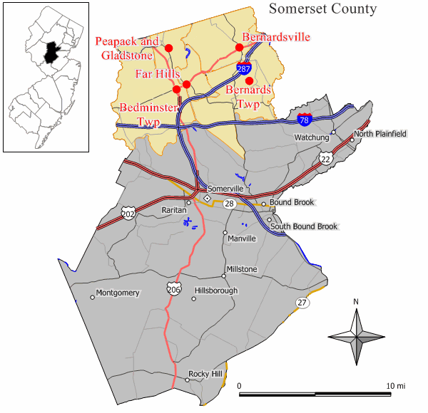
Bedminster, New Jersey Historic Sites
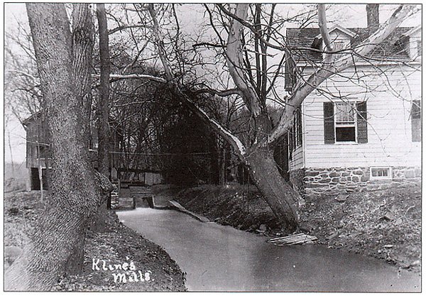
McDonalds/Kline’s Mills, Klines Mill Road (1)
Bedminster Township, New Jersey
Bedminster Township – 250 Years by Prich Matthews, page 21)
A 19th -20th century “up and down” sawmill was listed on the National and New Jersey Registers of Historic Places in 1986. Privately owned by the estate of John Kean, a forebear of former Bedminster Township Mayor John Kean (and cousin of former New Jersey Governor Tom Kean, the mill is located on the North Branch of the Raritan River where Kline’s Mill Road intersected with River Road before a storm took the bridge out in April 1995. A sawmill is said to have operated on the site as early as 1744. An 1850 map shows the Widow Kline’s gristmill, sawmill and store. Three generations of Kline’s owned the mill. The mill has a field stone foundation , a one story board and batten exterior, and 15 pane single sash windows.
Jacobus Vanderveer House, (2)
Also known as Knox House
Jct. of US 202 and 206, N of River Rd.,
Bedminster Twp., Pluckemin
(added 1995 – Building – #95001137)
Purchased by Bedminster Township in 1989 along with 218 acres, supported by the Friends of the Jacobus Vanderveer House and the Bedminster Historical Commission.
With its surrounding acreage, the Jacobus Vanderveer House is the last remaining site in Somerset County to have been associated with the locally prominent Vanderveer family. It is the only structure that remains intact from which to interpret the Vanderveer family and local Revolutionary War Activities.
While the period of historical significance is 1772, when the building was first built, the house reached its architectural apex in 1813, immediately following Mary Hardenburgh Vanderveers’ Federal style additions.
The Jacobus Vanderveer House is the last surviving building associated with the Vanderveers, a family prominent in Bedminster Township history from its earliest settlement through the 19th century.
General Henry Knox and his family lived in the house which served as his headquarters during the winter of 1778-79 while he was in command of the Continental Artillery. The c1772 Dutch American core of the Jacobus Vanderveer House is the only known extant building associated with the Pluckemin Encampment of 1778-79, which is considered to be the first installation in America to train officers in engineering and artillery.
The interior contains massive exposed beams as well as Federal, Greek Revival and Victorian woodwork. The house is owned by Bedminster Township and its restoration was completed in 2007….more
Learn more about General Henry Knox, visit the Henry Knox Museum website –
Jacobus Vanderveer House Museum
Lamington Historic District (A)
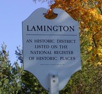
The Village is located on Lamington Road (Route 523), three and a half miles west of Bedminster Village, on a north south route. The name Lamington is derived from the Indian work Allametunk that means “place of clay”. Lamington is also the name of a village in Scotland. The earliest settlers were Scot-Irish Presbyterians, soon joined by Dutch and German families. It is not know exactly where the first colonists arrived, but the first appeal to the Presbytery of New Brunswick for a preacher was in 1739. Lamington supported the New Jersey Provincial Congress that declared independence from Great Britain on July 2, 1776.
Pluckemin Historic District (B)
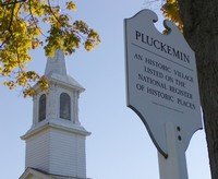
The village of Pluckemin (sometimes spelled Pluckamin in the history books) was known as Bedminstertown before 1755. In fact, some 28 spellings of Pluckemin have been discovered.
Some feel the origin of the names comes from the word Pluckamin, a dialect form of the Algonquin Indian Putchamin. Some think it came from a village name in Scotland. And others still think the name derived from the Pluckemin Tavern’s early keeper Jacob Eoff who, in luring customers into his premises by nailing a loose horseshoe to the ground on the road outside his tavern, knew the passers-by would certainly dismount to grab the shoe, and Eoff would “Pluck- ’em-in”.
German Lutherans came to Pluckemin in the early 1700’s. As early as 1715 they built a log church on Pigtail Mountain, east of the village off Mount Prospect Road and above Washington Valley Road. It was called Im Geberge (On the Mountain). The site and it’s cemetery were in the news in November 1998 when an article in the Bernardsville News when Toll Brothers, the Developer of The Hills Development, found more than two dozen bodies in a cemetery (now up to 66). The builder exhumed the remains and relocated them to a single grave in the Presbyterian Church on Pluckemin. While the headstones were moved to the Oldwick Lutheran Church, historians are hoping the original headstones will be placed at the single grave in Pluckemin.
The original tavern, owned by German, Jacob Eoff, who purchased 500 acres from the original Peapack Patent and John Johnstone’s estate, his property became Pluckemin Village where he established a tavern in 1750 (on the corner where the current A & P resides). Eoff’s farmhouse was north of the village where the current King’s Super Market presides.
The Pluckemin Encampment on Schley Mountain where Colonial militia were trained on artillery equipment are two reminders of the Township’s involvement in the Revolutionary War.
Historical sites include the 1751 House (Jacob Eoff’s daughter who married John Boylan. The red building stands today at the Courtyard at Pluckemin.
General George Washington’s headquarters were in Pluckemin (Fenner House) on January 4, 1777 after the Battle of Princeton. Notable people with him were Dr. Benjamin Rush , Generals Henry Knox, Nathaniel Greene, and John Sullivan. Legend has it that during the stopover, an officer rode his horse up the stairs to the second floor and back down. Indentation made by a horse’s shoes were said to have been visible on the stair steps.
After the Battle of Princeton, thirteen officers were quartered in the Fenner House. Over two hundred British soldiers were imprisoned St. Paul’s Lutheran Church. Washington attended funeral services on January 5, 1777 for Capt. William Leslie (a British soldier and friend of Dr. Benjamin Rush).
Washington and his wife stayed at the Fenner house in February 1779 after the French Alliance Ball that commemorated the first anniversary of the alliance of the King of France with the American Colonies. The house was demolished in 1942. The Daughters of the American Revolution placed a stone at the site, currently the site of Clerio Fine Food and Catering. In 1988 a replica “Fenner House” was built in 1988 by L.G. Construction Company. Marra Advertising presently occupies the building.
Another site is the Jacobus Vanderveer House, who bought 439 acres in 1743 just north of Pluckemin. On the estate, his son Jacobus II built the house where General Henry Knox would live during the winter and spring of late 1778 thru mid – 1779.
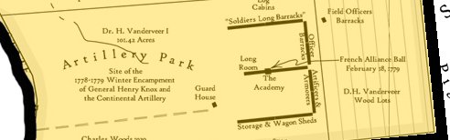
The Pluckemin Archaeological Project, (by Clifford Sekel, 1970’s) gives a rare account of the beginning and extend of General Knox’s artillery encampment, known today as the country’s first “West Point”. The Continental artillery park was located at Pluckemin, New Jersey, several miles north of the infantry camps. At this location, the artillerists built barracks for almost 1000 men and established a depot, repair facilities and an academy for artillery officers. This encampment was abandoned by the Army in June 1779.
In the 1980s, archaeological excavations by Rutgers University exposed the remains of the “Artillery Park” and recovered thousands of artifacts. For additional info on the Pluckemin Archaeological Project, Click Here.
Two artifacts found at Pluckemin have changed the view of the early American flag and its use by the Continental Army. These decorative belt tips probably adorned the ends of officers’ “over the shoulder” leather sword belts. Each belt tip is hand-engraved and bears almost identical designs of a cannon, flag staff, and flag, a motif very similar to that found on American artillery buttons of the period. These belt tips had never been seen before, and their use by the American army was previously unknown. What made them all the more spectacular was that they both showed a new orientation of the stars on the field of the American flag, five stars, over three stars, over five stars.
The colonial flavor of Pluckemin village is typical for this area of the state. George Washington may not have slept here, but he and his troops most certainly marched through Bedminster.
Source: (Booklet: Bedminster Township – 250 Years by Prich Matthews)
Pottersville Village Historic District (C)
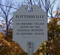
Pottersville owes it initial settlements and later development to the Lamington River used for early mills and manufacturing. The river separates two townships and two counties, Bedminster in Somerset to the east, and Tewksbury in Hunterdon to the west.
William Willet is said to have been the first settler at the village site in the early 1750s. His home was on the west side just below the falls. On the west side, he established a feed and flour mill and a fulling mill at an upper site. Both mills operated during the revolution, selling goods to the Continental Army. With the depreciating Continental currency, Willet declared bankruptcy and sold his mills to the Potter Family (Col. Samuel Potter), named Potter’s Mills. Samuel’s grandson, Sering Potter, built a new four mill in 1840 on the site of the destroyed one. When a post office was established, the village became Pottersville, and Potter became the first Postmaster. But even the Potter family had trouble, going into bankruptcy in early 1878, forcing the sale of all of the mills and assets.
The railroad reached Pottersville in 1889 with passenger and freight service. Known for growing and shipping peaches, in 1889, the Parkside Hotel was built by Henry “Whiskey Hank” Flemming, a local distiller. In 1892, he sold the hotel to Ellis Sutton, who renamed it Hotel Sutton. The railroad station was at the back of the Hotel. When the railroad closed in 1912, it too closed in 1912. The early dream of Pottersville being an ever-booming river-driven manufacturing center was not to be. It has become a quiet residential community with only a few local services. (excerpts from Bedminster Township – 250 Years by Prich Matthews)
Bernards Township, New Jersey Historic Sites
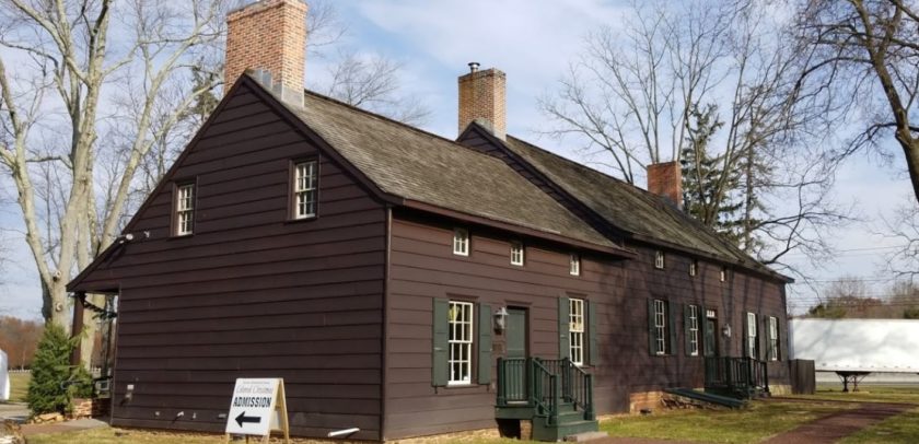
The Brick Academy (3)
15 West Oak Street, Basking Ridge section of Bernards Township
Basking Ridge Classical School (added 1976 – Building #76001185)
Also known as The Academy, The Brick Academy
Most Significant Person: Robert Finley.
The 1809 Federal-style Brick Academy, located in the center of Basking Ridge, has been a boys’ private preparatory school, a public school, a meeting hall for several fraternal and benevolent organizations, and the Bernards Township municipal building.
Alward Homestead / Alward Farmhouse/Chimney Ash Farm (4)
40 Mount Airy Rd, Basking Ridge, NJ
(aka Chimney Ash Farm)
Alward Farmhouse (added 1986 to the National Register – Building – #86000388)
Also known as Chimney Ash Farm, 40 Mt. Airy Rd., Basking Ridge. Built by Henry Alward.
Henry Alward, son of Henry Alward and Mary Cox, married Osee Pennington, daughter of John Pennington and Osee Doty Pennington.
Basking Ridge Presbyterian Church (5)
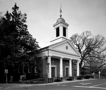
6 West Oak Street, Basking Ridge (added 1974 – Building #74001190) 6 E. Oak St., Basking Ridge.
The Basking Ridge Presbyterian Church, built before 1720, stands alongside one of the oldest white oaks in the Western Hemisphere, estimated to be more than 600 years old. Both General Washington and Lafayette are known to have met under the giant oak, and Colonial troops often stopped here to rest. About 35 Revolutionary War soldiers are buried in the well-preserved graveyard under the tree adjoining the church.
The video below is a great historic piece honoring the sermon of the late Dr. Robert Finley, an early Basking Ridge Presbyterian Church pastor. Listen as Pastor Jones recreates this great sermon.
Historical Essay- The Presbyterian Church, Basking Ridge, NJ – A History 1717-1968 by Dorothy Loa McFadden, Mildred Van Dyke and Eileen Luz Johnston.
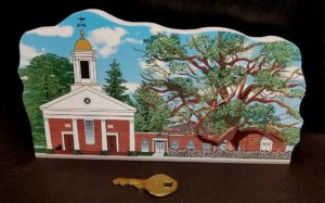
Own a piece of local history. The Basking Ridge Presbyterian Church at the iconic Basking Ridge Oak Tree, part of the New Jersey Historic Cat’s Meow wooden collectible series.
Coffee House, (6) (aka 1804 House)
Coffee House (added 1977 – Building #77000906) 214 N. Maple Ave., Basking Ridge.
The Coffee House on North Maple, constructed in 1804, is an example of a New Jersey frame farm house. It served as a residence and a crossroads tavern, and was a center of activity and entertainment for the local farms and communities in the early 19th century.
Winner of the 2005 local Historic Preservation Award
Kennedy Martin Stelle Farmstead (7)
Kennedy–Martin–Stelle Farmstead (added 2004 – District #03000868)
450 King George Rd., Bernards Township (Basking Ridge)
The historic Kennedy-Martin-Stelle Farmstead, a National Register site located at 450 King George Road in Bernards Township, is being preserved and operated by the Friends of the Kennedy-Martin-Stelle Farmstead.
Lord Stirling Manor (8)
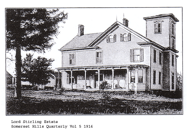
Site, 96 Lord Stirling Road, Bernards Twp. Note: The House is no longer standing.
Lord Stirling, a Major General in the Continental Army, moved to his country
manor at Basking Ridge in 1768, where he raised flax, apples and bred horses. There was also a three-story brick dwelling, stables, a coach house, and other outbuildings.
Only two small brick outbuildings, dating from the early 19th century, remain. Archaeological investigations are taking place on the site, and plans are underway to restore the outbuildings. The site hosts an annual 1770s festival in October. (See Events).
Lord Stirling achieved the rank of Major General, born in 1726 and died in 1783. He is buried in Albany NY at the Albany Rural Cemetery.
Notable tidbits about William Alexander (Lord Stirling:
Stirling was noted as one of General Washington's most trusted military leaders in the Continental Army.
The town of Stirling NJ is named after him.
He never was officially given the title of Lord by the House of Lords in England.
General Lord Stirling was the presiding Judge at the Court Martial of General Charles Lee after the battle of Monmouth. General Lee was famous in Basking Ridge for being captured by the British at the Widow White's Tavern on December 13, 1776. Lee was declared Guilty, confirmed by Congress and subsequently stripped from his rank.
Alexander was involved heavily in the slave trade in his years before the revolution.
Stirling had a number of bouts with Bankruptcy before, during, and after the Revolutionary war.
(Source – William Alexander, Lord Stirling by Paul David Nelson -1987 ISBN: 0817302832 )
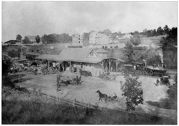
Lyons Train Station (9)
Lyons Road, the Lyons section of Bernards Township
A one-story Tudor Revival-style structure built in 1931, was designed by noted architect, D.T. Mack.
One of the stopping points of what was earlier known as the “Millionaires Express”.
The Boudinot Southard Ross Estate (13)
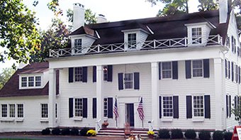
(Pronounced Boo -Din-know)
Placed on the New Jersey and National Registers of Historic Places Sept. 11, 2009 and Dec. 18, 2009 respectively.
The fifty-acre Boudinot-Southard-Ross property, which borders the Basking Ridge Country Club and Lord Stirling Park, has three historic buildings: a house, barn, and outbuilding. Elias Boudinot built the original house in 1777, which retains some early details. The property is surrounded by preserved open space and offers wonderful panoramic views.
Franklin Corners Historic District (D)
(470 acres, 11 buildings)
Franklin Corners Historic District (added 1975 – District #75001159)
N of Bernardsville on Hardscrabble and Childs Rds. and U.S. 202, Bernardsville
Entered in the State Register
December 12, 1974
(ID #2472)
Entered in the National Register
May 12, 1975
(NR Reference #75001159)
Samuel Johnson House
Van Dorn’s Mill
Franklin Corner School
The Grain House
Mr. Local History wrote a detailed story about the historic district – Click Here
Liberty Corner Historic District (E)
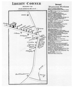
(added 1991 – District #91001477)- Also known as Liberty Corner
Roughly, jct. of Church St. and Valley and Lyons Rds., and area W and SW, Bernards Township, Liberty Corner
1722 – John Annin, officially known as John Johnston of Annandale, Scotland, arrives in Bernards and takes title to 1,000 acres. The settlement was known as Annin’s Corner.
In 1766, William Annin, son of John Annin, built an old stone house with rocks from the neighboring quarry. There are initials on these blocks “W.A” and “H.S.M”, along with the date, indicating the Builder (William Annin) and the mason (Hugh Sunderland).
The name was changed from Annin’s Corner to Liberty Corner sometime during the American Revolution. However, the area was also mentioned as Bullion’s Tavern during the war.
While the Annin stone house was destroyed, it was located just across from the present day English Farm, site of the Rochambeau Revolutionary trail through Liberty Corner (See Events), in August 1781, when the area was called Bullion’s Tavern (for the tavern that was located in the center of town). Additional Photos and maps are in the Photo archive section.
Basking Ridge Historic District
ID 2469- Area between North and South Finley, North and South Maple Aves., Lewis, West Craig, and Oak Street. DOE- 8/18/1994
Bernardsville, New Jersey Historic Sites
Bernardsville Train Station
US Route 202 (10)
One of the stopping points of what was earlier known as the “Millionaires Express”.
John Parker Tavern (The Old Bernardsville Library)
2 Morristown Road (11)
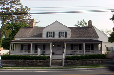
The gray building that housed the Bernardsville Public Library for over ninety years was originally called the Vealtown Tavern and later the John Parker Tavern. Constructed in the 1700s, the tavern was a stopover for the weary and thirsty, an inn for passersby, and, for a time, served the officers and men of the Continental Army, and lore tells of a ghost as well.
Reynolds – Scherman House
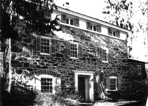
71 Hardscrabble Rd, Bernardsville, New Jersey(12)
(National and State Historical Listing added 1989 – Building – #89000298)
The Stone House was built around 1770 and was reported to have been used as a commissary for Washington’s Colonial Troops during the American Revolution. The Hoffman building, located in the foothills of the Highlands, now houses the Scherman Hoffman Wildlife Sanctuary offices.
Constructed as a barn originally, the structure was converted into a residence in the early 1800s. All of the property, the structures, and the land are now on the New Jersey and National Registers of Historic Places. While the home was a private residence, it was carefully restored with authentic materials of the period.
Architect, builder, or engineer: Unknown
Architectural Style: Early Republic, Colonial Revival
Historic Person: Scherman,Harry
The Scherman-Hoffman Wildlife Sanctuary, located in Bernardsville, Basking Ridge, and Harding Township, NJ, has its beginnings in the 1965 donation of 125 acres by Mr. and Mrs. Harry Scherman to the New Jersey Audubon Society. Later, in 1973 and 1975, Mr. G. Frederick Hoffman donated parcels of land. The Hoffman estate house and caretaker’s house were added to the Sanctuary in 1981, at the time of Mr. Hoffman’s death. This completed what is now the Scherman-Hoffman Wildlife Sanctuary, 276 acres of woodland, field, and floodplain habitat supporting over 200 species of wildlife over the course of a year.
Born in Montreal, Canada, in 1887, Harry Scherman was a highly resourceful marketer and a devout reader. He believed that the love of reading and of owning books could be effectively marketed to the “general reader,” an audience often neglected in the book publishing industry of that period. Scherman’s first book marketing scheme involved a partnership with Whitman Candy, in which a box of candy and a small leather bound book were wedded into one package. These classic works, which he called the Little Leather Library, eventually sold over thirty million copies.
Scherman’s ultimate goal was to create an effective means of large-scale book distribution through mail order. The success of direct-mail marketing had already been proven in other industries by the 1920s, but no one had figured out how to successfully market books in this fashion. The difficulty was in applying a blanket marketing approach to a group of unique titles with different topics and different audiences. Scherman’s solution was to promote the idea of the “new book” as a commodity that was worthy of ownership solely because of its newness. His approach focused attention on consumers owning and benefiting from these new objects, rather than on the unique qualities of the objects themselves. In 1926, Scherman’s idea came to fruition, and with an initial investment of forty thousand dollars by Scherman and his two partners, the Book-of-the-Month Club was born.
See also Scherman Hoffman Wildlife Sanctuary
Olcott Historic District
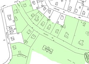
Just North of Route 202/206 in Bernardsville, New Jersey
(Green area)
Olcott Avenue is named after Frederick Pepoon Olcott (1841-1909), a Bernardsville mountain colony resident who was president of the Central Trust Company in New York, which later merged with JP Morgan. Olcott owned a Bernardsville estate that included the Somerset Hills Country Club.
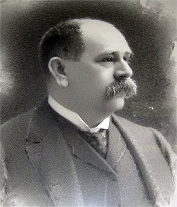
In 1905, a local resident, Frederick P. Olcott, bought twenty-seven acres of what was then known as the Wolfe tract of what is now Olcott Avenue for $10,000. He erected the present stone nine-room Olcott Building at a cost of approximately $100,000 and presented the property to the Bernards Township school district (Bernardsville was still part of Bernards Twp until 1924).
This building served as the first high school in Bernards Township and also housed Bernardsville’s elementary grades. That building was designed by architect Henry Janeway Hardenbergh. Hardenbergh was also the architect for the Plaza Hotel, the Waldorf Hotel, and the Dakota Apartments in New York City, Lincoln said.
While the Olcott Avenue School is but one historic structure within Bernardsville’s first historic district area, the area’s appeal and historic significance remember the story of the rise of the middle class in Bernardsville and how this particular location impacted the entire region, including the downtown, Little Italy, and even the Mountain Colony areas.
Click here to read some of the memorable and historic moments and commentary from the Historic District Nomination Forms that were submitted to the New Jersey Historic Preservation Office.
Morristown National Historical Park – NJ Brigade (F)
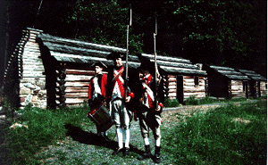
When soldiers first arrived in Jockey Hollow for their winter encampment, they had no choice but to sleep out in the open in the snow. Wagons with tents arrived a few days later than the soldiers. Soldiers remained in the tents until the wooden huts were completed. The soldier huts used at Jockey Hollow were fourteen feet by sixteen feet and housed twelve men.
General Washington ordered that enlisted men’s huts were to be built first. Therefore, Officers’ huts were not built and completed until all the enlisted men were settled in huts. It took most of the soldiers about two to three weeks to build their huts. Most of the enlisted men in the Continental Army were poor, lower-class. A good number of these men were not even born in America.
Far Hills, New Jersey Historic Sites
Far Hills Train Station
One of the stopping points of what was earlier known as the “Millionaires Express”.
Alexander and James Linn Homestead
Alexander and James Linn Homestead
Mine Brook Rd (22)
Rt. 202/Mine Brook Rd., between Sunnybranch Rd. and Lake Rd., (Just North of the Far Hills Train Station, Far Hills)
Also Known as Linn House or Linnfields, Mayfields
Linn, Alexander and James(son), Homestead (added 1988 – Building – #88002057)
Built in the mid-1700s by Alexander Linn, it later became the home of his son James. Alexander was a Judge of the Court of Common Pleas, and a Member of the Provincial Congress of New Jersey in 1776; during the Revolutionary War served as captain in the Somerset County Militia in 1776.
LINN, James, a US Senator from New Jersey; born in Bedminster Township, Somerset County, N. J., in 1749; pursued preparatory studies and was graduated from Princeton College in 1769; studied law; was admitted to the bar in 1772 and commenced practice in Trenton, N. J.; returned to Somerset County, N. J. James served as a Major in the Somerset County Militia during the Revolutionary War under Lord Stirling (from Basking Ridge).
Significant Year: 1850, 1750
Peapack & Gladstone, New Jersey Historic Sites
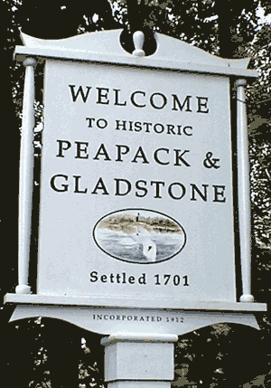
1701 – The “Peapack Patent” of 1701 transferred lands from 24 proprietors of East Jersey to George Willocks and John Johnstone.
On June 6, 1912, Peapack and Gladstone set off from Bedminster Township and incorporated as an independent twin borough.
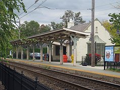
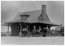
Gladstone Train Station
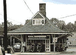
One of the stopping points of what was earlier known as the “Millionaires Express”.
(added 1984 – Building – #84002792)
Main St., Gladstone
Architect, builder, or engineer: Unknown
Architectural Style: Queen Anne
Area of Significance: Transportation, Architecture
Period of Significance: 1875-1899, 1900-1924
Peapack Limestone Kilns
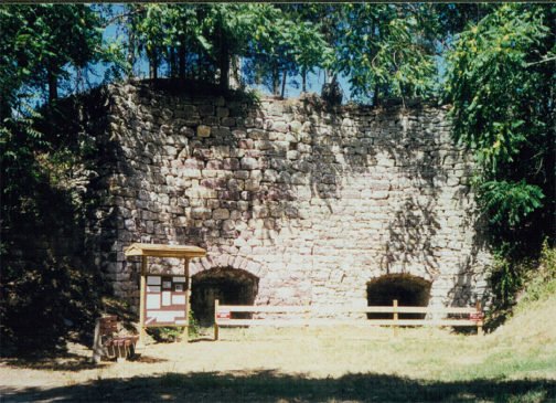
Located on the east side of Main Street in Peapack, the Peapack Limekilns were donated to a local historical society in 1997, when the adjacent property was being developed as a residential subdivision. That society created a pocket park featuring the kilns that was dedicated in May 1999 and is open to the public. The preserved kilns serve as an important reminder about the agrarian heritage of the Somerset Hills.
A lime kiln operation existed in Peapack as early as 1794. By that time agricultural land in New Jersey was “wearing out,” and an important use for lime was as a soil additive used by farmers to increase the yield of their crops. Many farmers burned limestone in small kilns on their property, but the Peapack kiln was a commercial operation. Lime was also an important ingredient in mortar and whitewash. Lime would also have been used in the early leather-tanning factory that was located beside the Peapack River south of the kilns. An 1848 daybook kept by John Stelle, a farmer in southeast Bernards Township, records numerous trips to Peapack for lime during the winter months when roads were frozen or snow-covered, making the 20-mile round-trip wagon journey easier than during the warmer months when mud frequently made roads nearly impassable.
The Peapack area was a good source for limestone, which was quarried in the nearby vicinity well into the 20th century. The quarried limestone was loaded into the limekiln from the top, alternating with layers of fuel, such as charcoal early on and eventually coal. After burning for about 60 hours, the lime was removed from the bottom of the kiln.
The Peapack kiln is composed of two adjacent kilns separated by a vertical joint visible in the stone wall, which suggests they may have been constructed at different times. The front wall, constructed of hewn stone, is 26’ high and is set into the side of a hill that provided easy access to load the limestone and fuel from the top.
Notable Historic Additions Not on the Registries
English Farm – Bernards Township (Liberty Corner)
Situated in the picturesque and historic village of Liberty Corner, the working farm has been in the same family since before the Revolutionary War.
Back in the late Summer of 1781, this farm site was where over 4,000 troops, 1,500 horses, and a herd of over 600 oxen congregated at what was then known as Bullions Tavern (Liberty Corner / Bernards Twp) . The site recently commemorated the 225th anniversary of the march of French and continental forces through New Jersey to their victory over the British at the Battle of Yorktown. A reenactment on the English Farm, the actual location of the French campsite, was recently performed recreating August 29, 1781.
Additional history of the English Farm- Click Here
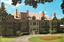
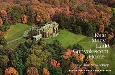
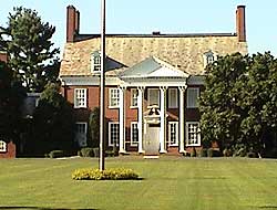
Natirar – (Kate Macy Ladd) Peapack Gladstone /Far Hills / Bedminster
One of the most famous anagrams (a word spelled backwards) around the Somerset Hills is the name Natirar. Natirar, the anagram of the word Raritan, for the Raritan River that runs through the infamous estate.
491 acres – Purchased by Somerset County NJ in 2003 for $23 million to create a new park for low-impact recreation such as hiking and biking, mixed with an occasional concert or crafts fairs.
The Natirar Mansion sits at the end of a 1.25-mile driveway within a 491-acre estate that occupies portions of three municipalities. (The main buildings and 327 acres are in the Borough of Peapack and Gladstone; 124 acres are in the Borough of Far Hills; 40 acres are in the Township of Bedminster.) The main entrance, once at the Far Hills train station, is now just over the town line, nearly at the spot where Main Street (Peapack Road) crosses the North Branch of the Raritan River and New Jersey Transit’s Peapack Gladstone railroad branch.
British tycoon Sir Richard Branson will transform 80 Acres of the 491-acre estate, The Natirar Mansion, into the Spa at Natirar. Natirar is historically remembered for the estate created by Walter Graeme Ladd (1857-1933) and his wife, Catherine Everit Macy Ladd (1863-1945), who began to acquire estate land in April 1905, naming it Natirar ( Raritan backwards) for the Raritan River that flows through the property. The estate includes 22 buildings, many historic, six wells, three bridges, three streams, a pond, and woodlands. The 33,000 square-foot mansion itself, grand that it may be, is sedate and austere.
Kate Macy and Walter Ladd began acquiring property in the Somerset Hills in 1905. Macy was a Quaker heiress to a whaling/oil/shipping fortune; her father’s business partner was John D. Rockefeller. Ladd was an entrepreneur and attorney to John D. Rockefeller. They married in 1883 and rented property in Bernardsville as they acquired small local farmsteads until their estate spread over 1,000 acres throughout Peapack/Gladstone, Far Hills, and Bedminster.
The main entrance lane ambles upward as the stream turns away, then leads through woodland until it emerges on a hilltop, with stone cottages and a stable in view. Then, it swings in front of a small “castle.”
Moroccan (NW Africa) King Hassan II bought the property from the Ladd Estate in 1983 but he never permanently lived there. Somerset County bought Natirar from his Hassan II’s son, King Mohammed VI of Morocco in 2003 for $22 million.
The Branson-Wojtowicz development partnership and its co-applicant, the Somerset County Improvement Authority (SCIA), were seeking board approval for 143,000 square feet of new construction at the estate. The mansion, two cottages, carriage house, and greenhouse stand on 88 acres that the county leased to Sir Richard Branson, which was later dissolved. Branson is no longer involved in the project.It is noted that the non-spa area (aka the park), containing some 400+ acres, opened to the public in the Fall of 2006.
Original Architects-
Guy Lowell & Henry Hardenberg- who also designed The Plaza Hotel, The Dakota, Manhattan Courthouse, and the Boston Museum of Fine Art.
Additional Information:
See the actual Kate Macy Ladd Convalescent Home Brochure- Visit the Archives Section
See For Sale Article June 13, 1982 – NY Times Article – Click Here
To see additional recent photos and the outer cottages and garages- Click Here
Update
Natirar/Restaurant/Spa/County Park
The 491 Acre preservation effort, was purchased in 2003 for $22 million Somerset County Improvement Authority. In the first 30 years of a 99 year lease, the 80 Acre lease to Virgin Atlantic’s Richard Branson will return $25.7 million. A portion of the remaining funds will be used to develop the remaining 411 acres.
If the estate had been sold to developers, with current zoning laws, it could have been 50 homesites and the mansion would probably have been lost stated Somerset County Freeholder, Rick Fontana, who worked on the acquisition effort.
The property includes some 13,000 feet of stream frontage, 189 acres of forest, 230 acres of former agricultural land and 44 acres of wetlands. The property is set to become a county park, managed by the Somerset County Park Commission, which opened it’s first portion in 2009 with a new restuarant and culinary school.
Source: Somerset County Board of Chosen Freeholders Newsletter – Fall 2006
USGA Golf Museum – Far Hills
(Actually is in Bernards Township)
The USGA museum is located on a 60-acre estate.The USGA’s facility at Far Hills documents the game’s rich history and is home to the most sophisticated and technically advanced golf equipment test facility in the country.
Constructed in 1919, built for Thomas Frothingham. In 1926, Thomas Frothingham’s Dogwood estate (now USGA Golf House Museum) was sold to John Sloan, a prominent furniture retailer, due to bankruptcy as a partner of investment company Potter Brothers & Company. After a failed suicide attempt, a divorce from his wife, and moving to Mexico to avoid bankruptcy prosecution, Frothingham died in Mexico.
Click Here to read the historic profile of the USGA Museum
US Equestrian Team Foundation Headquarters – Gladstone
The Hamilton Farm estate is home to the United States Equestrian Team Foundation.
Besides being the training site for horses and riders that participate in Olympic events, it is also the venue for the annual U.S. Equestrian Team Festival of Champions, a four-day extravaganza of horsemanship, including driving, show jumping and dressage, normally held annually in the third week of June.
Essex Hunt Club – Peapack
The Essex Hunt Club is a fox-hunting club that evolved into two private clubs, Essex Fox Hounds, which still hunts, and the Essex Hunt Club, a winter recreational club on a property of more than 100 acres that uses an ice rink for figure skating and hockey. Masters of Foxhounds Association of North America is the sanctioning body in the US for what the organization entitled the Essex Fox Hounds, that was spun from the original Essex Hunt Club.
W. Raymond Cross Estate & Gardens – Bernardsville
Site of the New Jersey Brigade Unit of Morristown National Historical Park, on Old Jockey Hollow Road in Bernardsville, NJ.
The original house, built by John A. Bensel in 1905, formed the centerpiece of his “Queen Anne Farm.” The estate included a carriage house, a five-story stone water tower, and a gate house.

In 1929, W. Redmond Cross purchased the property and renamed it “Hardscrabble House”. His wife, Julia Newbold Cross, was a member of the Royal Horticultural Society for eight years. Mrs. Cross made extensive improvements in the garden with the help of Clarence Fowler, a noted landscape architect. Together, they cultivated an unusual assortment of plants throughout the garden. The house was extensively remodeled in 1940, after the death of Mr. Cross.
The Cross Estate Gardens are a project of the New Jersey Historical Garden Foundation, in cooperation with the National Park Service.
Additional Information
- Check our our complete YouTube video series of additional homes, estates, properties, and other fun videos.
- USGA Museum historic profile
- The infamous Blairsden Estate (Peapack)
- The Historical Marker Database
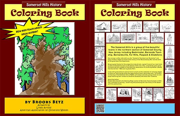
Almost every property listed in this story is part of the Somerset Hills History Coloring Book. To support our education programs, one book from each purchase is donated to a local children’s education program.
Please support our efforts and purchase at least one of these great coloring books.